
Wild Horse Sunset
Wild Horse Sunset
Near Hanksville, UT
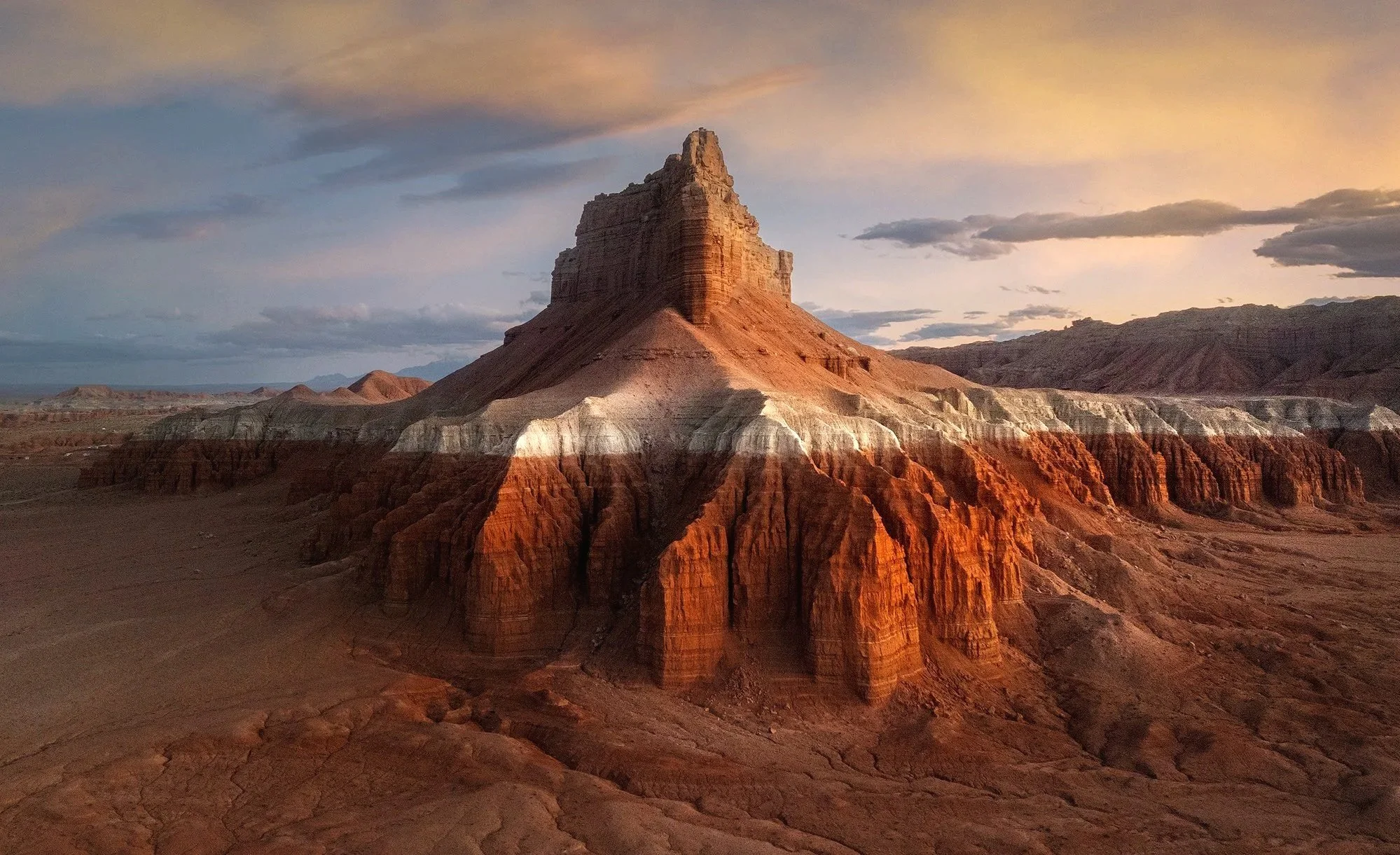
The areas surrounding Hanksville, UT, provide some of the best landscape photography opportunities in the American Southwest. However, capturing these views from the sky elevates this area from great to extraordinary.
I had driven past this location many times and was always intrigued by the unique formation, but I struggled to find a way to highlight its distinct shapes and vibrant colors. Then it hit me: McFly! You have a drone! This unique drone perspective helps to showcase the powerful formation and colorful striations of the butte.
If you travel to the Hanksville area, bring your camera. And if you don’t have a drone, buy, rent, borrow, or steal (just kidding) one! There are endless possibilities seen from above.
Images and location summary by Tim Wier
Trail Difficulty - MODERATE
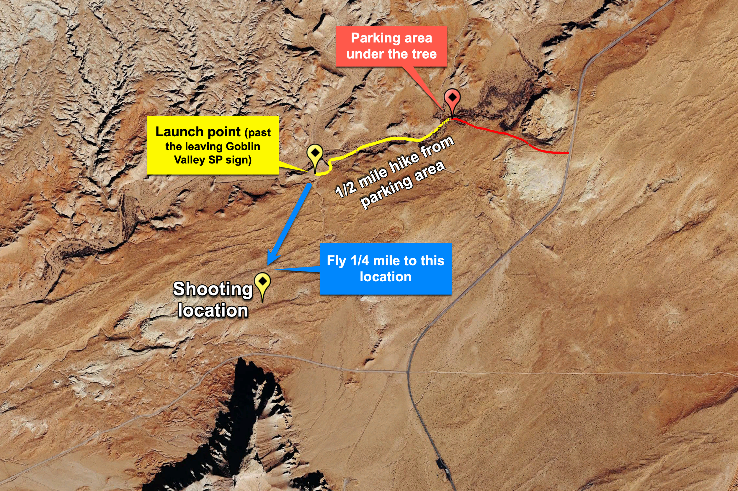
I would rate this trail's difficulty as a 3 on a scale of 1 to 5, with 5 being the most difficult. To reach the launch site for your drone, you need to hike along a shallow creek bed for about a half mile, then hike up a short sandy hill. The total hike is about 0.6 miles each way, with very little elevation gain.
GPS Coordinates & Elevation
38°35'36.0"N 110°42'58.3"W Launch location
38°35'09.7"N 110°43'06.1"W Location of shot
4,912 Ft. Elevation
Download KMZ Trail File
Click Here to download the KMZ file for this location.
Photography Tips
This location is best photographed 15-20 minutes after sunset. This allows the reflective light from the sky to illuminate the buttes and ridges with a soft, warm glow and prevents the wonderful red colors from blowing out. This is only possible when there are NO CLOUDS in the west and the skies above the butte. You can photograph the butte at sunset. However, the very best time to capture this is 15-20 minutes after sunset (trust me).
If there are clouds in the west and above the butte, your best chance to photograph the location is during the very last light before the sun dips below the horizon.
Directions
From Hanksville - from Hanksville, drive north on UT-24 for 19.6 miles until you see a sign for Goblin Valley State Park. Turn left onto Temple Mountain Road and continue for 5.2 miles. At this point, turn left again and drive 5.1 miles toward Goblin Valley State Park. You will find a turnoff for CRACK CANYON ACCESS on the right.
Take this paved/then dirt road for approximately 0.4 miles, where you will see a small parking area beneath a large cottonwood tree. Park here and walk west along a shallow creek for 0.5 miles until you see a sign stating "LEAVING GOBLIN VALLEY STATE PARK." Once you cross the boundary, walk up the hill to your left—this is where you will launch your drone.
SPECIAL NOTE: If you follow the route shown above, both the launch point and location of the shot are NOT in the Goblin Valley State Park. However, you will be driving through parts of Goblin Valley State Park to get to the location, so obtaining a Goblin Valley permit is advised. You can get this at the information center at the state park entrance.
Though this shot does not require a Goblin Valley Drone Permit, you can purchase one at the information center if you choose.
Google Earth
EXIF Data
Focal Length – 24 mm
Exposure – 1/5 sec sec @ f 8.0
ISO – 900
Date – March 30th
Time – 7:25 pm
Best Time of Day to Shoot
This shot is best about 10-15 minutes AFTER sunset.
Best Time of Year
This location is best photographed in spring and fall when the sun is perpendicular to the butte, creating nice side-lighting. You can also shoot in summer and winter, but during these seasons, the angle of the sun is not perpendicular, which changes the side lighting on the butte.
Lens(es) Needed
This shot was taken with the wide-angle 24 mm lens on a Mavic 3 Pro.
Birds-Eye View From Google Earth Pro
Permits
If you follow the route shown above, both the launch point and the shot location are NOT within Goblin Valley State Park. However, you will be driving through parts of Goblin Valley State Park to get to the location, so obtaining a Goblin Valley permit is advised. You can get this at the information center at the state park entrance.
Goblin Valley allows drone flight by purchasing a Drone permit (Monday through Thursday). Though this shot does not require a Goblin Valley Drone Permit (as you will be on and over BLM land), you can purchase one at the information center if you choose.
Direction of the Shot
The direction of the shot is south at around 180°.
Equipment Needed
A drone with a wide-angle lens.
Number of Other Photographers to Expect
At sunset, you will likely be the only person at this location.
Weather
The area surrounding Hanksville has a high desert climate, sitting at an elevation of around 5,000 feet. Daily temperature fluctuations can vary by 30 to 40 degrees. Spring and fall offer pleasant weather, but summer temperatures can rise into the high 90s.
Cell Service
I have Verizon, the cell service in this location good.