
Rise and Shine
Rise and shine
Near Hanksville, UT
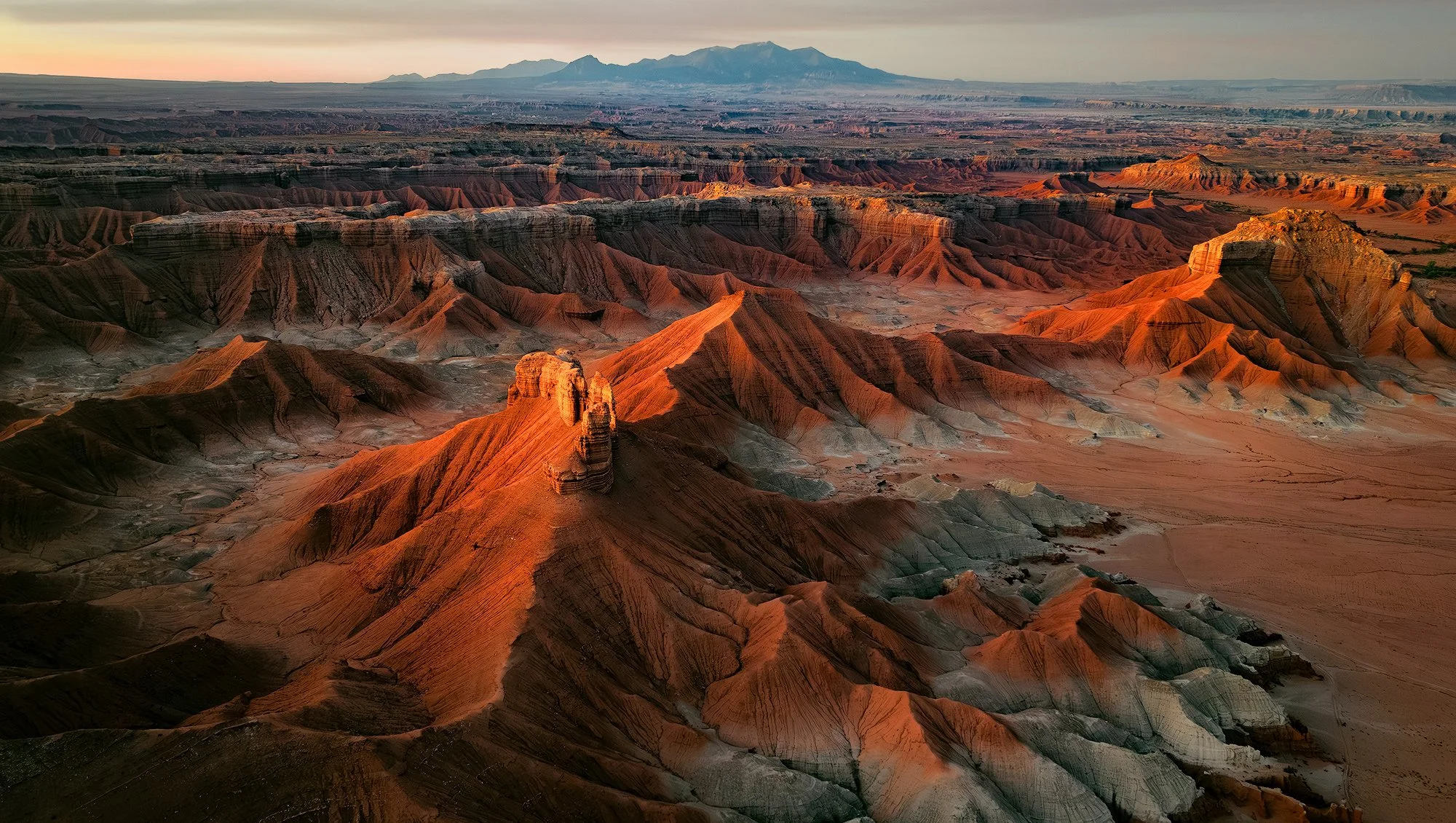
The area surrounding Hanksville, UT, is one of the most fascinating landscapes in the American Southwest for drone photography. The badlands feature endless abstract patterns, buttes, colorful bentonite hills, intriguing formations, and breathtaking vistas, making it a paradise for drone pilots.
The unique perspective provided by a drone can greatly enhance this already rich area for photography. Viewing the badlands and bentonite hills from above brings this incredible landscape to life, leaving photographers in awe and wondering how such formations came to be.
Images and location summary by Tim Wier
Trail Difficulty - MODERATE
I would rate the difficulty of this trail as a 3 on a scale of 1 to 5, with 5 being the most difficult. To reach the location for this drone shot, you will need to drive along a bumpy dirt road that has significant ruts, which can vary depending on the time of year. Some scrambling may also be required.
Please note that this dirt road may become impassable when the ground is wet or muddy.
GPS Coordinates & Elevation
38°33'29.8"N 110°45'18.7"W Launch location
38°33'59.7"N 110°44'34.2"W Location of shot
5,011 Ft. Elevation
Download KMZ Trail File
Click Here to download the KMZ file for this locati
Photography Tips
This location is best photographed 10 - 15 minutes before sunrise. This allows the reflective light from the sky to illuminate the buttes and ridges. Once the sun hits the ridges of this scene, the shot will be BLOWN out.
I suggest arriving at least 30 minutes before sunrise (or scouting the location the day before) to know where you are going to fly to set up your composition. It is important to photograph this scene for several minutes.
Directions
From Hanksville - drive north on UT-24 for 19.6 miles until you see a sign for Goblin Valley State Park. Turn left onto Temple Mountain Road and drive for 5.2 miles. At this point, turn left again and drive 6.1 miles toward Goblin Valley State Park, where you will find a turnoff for Little Wild Horse Canyon. Take a right onto Wild Horse Road and drive for 1.8 miles until you reach a remote camping area, marked by a kiosk.
From the remote camping area, the road can become quite bumpy and rutted, with some deep dips. Follow the dirt road (be sure not to enter any campgrounds) for about 1.6 miles until you see a small sign that reads "LEAVING GOBLIN VALLEY STATE PARK." Once you are outside the park, you will be in BLM (Bureau of Land Management) land, where you are permitted to fly your drone.
From this location, fly your drone south and then west toward (see below) the buttes to the west. The shot will be facing south toward the Henry Mountains.
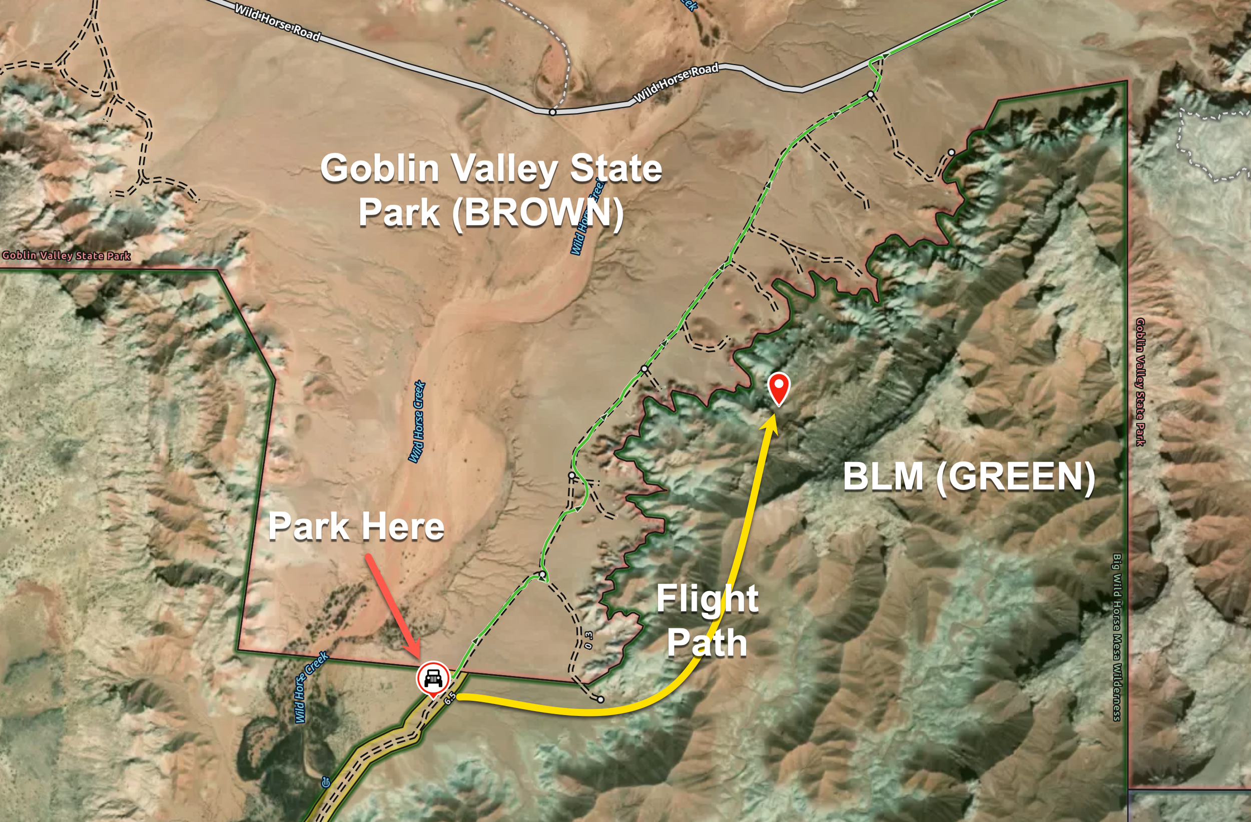
SPECIAL NOTE: the location of the launch point and photograph is in and over BLM Land. However, you will be driving through parts of Goblin Valley State Park to get to the location. Goblin Valley allows drone flight by purchasing a Drone permit (Monday through Thursday). Though this shot does not require a Goblin Valley Drone Permit (as you will be on and over BLM land), you can purchase one at the information center if you choose.
The map below shows Goblin Valley State Park in BROWN and BLM land in GREEN.
Google Earth
EXIF Data
Focal Length – 24 mm
Exposure – 1/15 sec sec @ f 2.8
ISO – 350
Date – Sept 13th
Time – 6:53 am
Best Time of Day to Shoot
This shot is best about 10-15 minutes BEFORE sunrise.
Best Time of Year
This location is best photographed during the spring and fall months. In summer and winter, the sunrise angle alters the side lighting on the buttes and ridges.
Lens(es) Needed
This shot was taken with the wide-angle 22 mm lens on a Mavic 3 Pro.
Birds-Eye View From Google Earth Pro

Permits
FAA Operational Waiver - you can shoot this scene below 400 ft above ground level (AGL) by climbing up the ridge to the south. If you wish to fly above 400 feet, you will need to obtain an FAA Part 107 Operational Waiver.
Goblin State Park - the location of the launch point and photograph is in and over BLM Land. However, you will be driving through parts of Goblin Valley State Park to get to the location. Goblin Valley allows drone flight by purchasing a Drone permit (Monday through Thursday). Though this shot does not require a Goblin Valley Drone Permit (as you will be on and over BLM land), you can purchase one at the information center if you choose.
Direction of the Shot
The direction of the shot is south at around 170°.
Equipment Needed
A drone with a wide-angle lens.wide angle lens.
Number of Other Photographers to Expect
At sunrise, you will likely be the only person at this location.
Weather
The area surrounding Hanksville has a high desert climate, sitting at an elevation of around 5,000 feet. Daily temperature fluctuations can vary by 30 to 40 degrees. Spring and fall offer pleasant weather, but summer temperatures can rise into the high 90s.
Cell Service
I have Verizon, but the cell service in this location is spotty. A stronger cell signal is available as I get near Goblin Valley State Park.