
Sentinel Jay Joshua Tree NP

SENTINEL JAY
Joshua Tree National Park, CA
Image by Rob Strain @ www.robstrain.com
Joshua Tree National Park is a favorite location for photographers due to its many shapes and the silhouettes of Joshua trees against the early and late day sky. Jumbo Rocks Campground is a favorite among all these locations. Many of the rock formations are in attractive shapes. Unlike many of the locations around Joshua Tree NP your compositions are unlikely to include rock climbers.
This simple to get to location is right in the campground. White Tank Campground is six miles away. There you will find Arch Rock, a great foreground for your night sky shots. As you drive around the park, look for Joshua trees with personality. You will want to come back to these when time permits.
Photos and location summary by Rob Strain.
Trail Difficulty - EASY
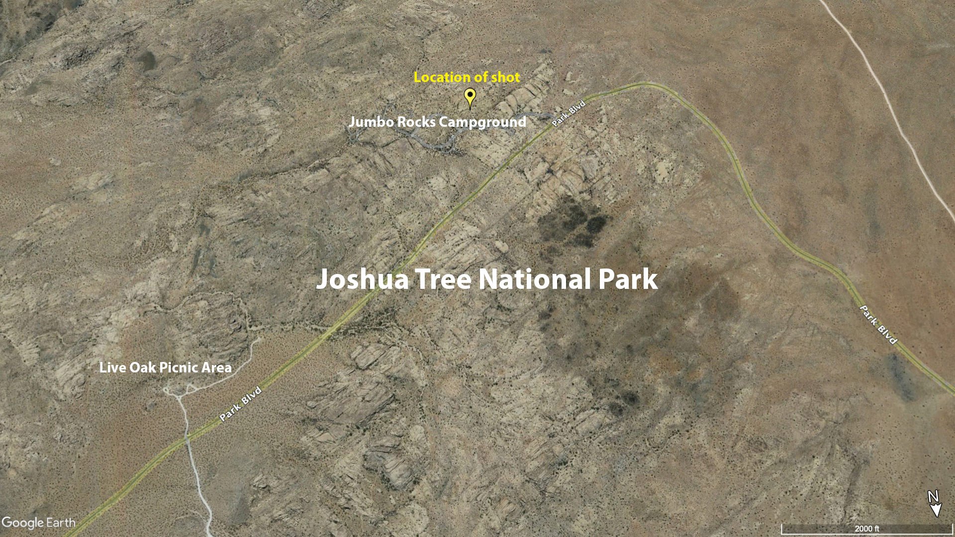
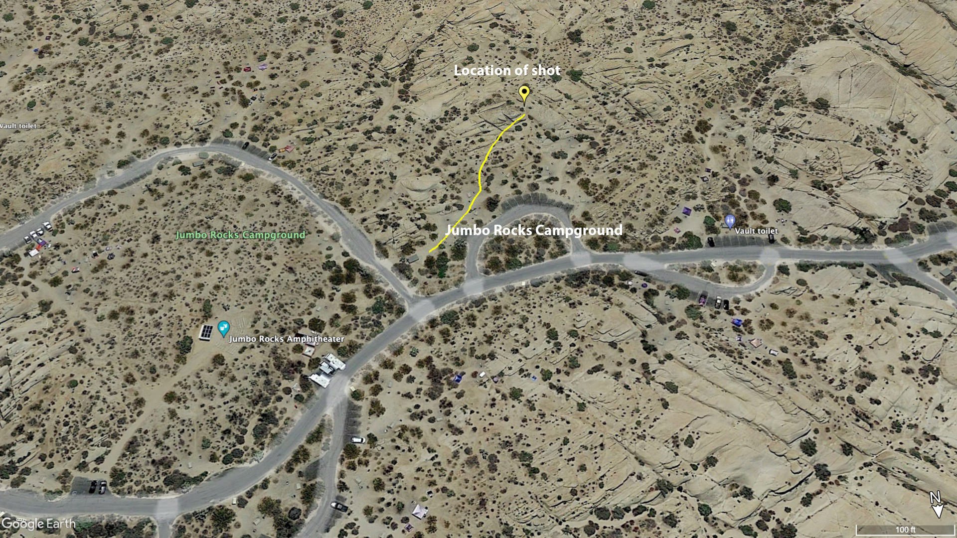
I would rate the difficulty of this trail as a 1 on a scale of 1-5 (with 5 being most difficult). The location of the shot is a simple 100 ft walk up a gentle slope from campsites 18 and 19 in the Jumbo Rocks Campground.
GPS Coordinates & Elevation
4,380 Ft. Elevation
View In Google earth
Directions
CLICK HERE to get driving directions to Jumbo Rocks Campground
From Palm Springs - Take CA-62 (Twentynine Palms Highway) for approximately 14.5 miles into the community of Yucca Valley. Turn right onto Sage Ave and then turn left onto Yucca Trail and travel 3 miles and continue onto Alta Loma Rd for another 3 miles. Turn right onto Quail Springs Rd and drive 4.1 miles. Drive for 17 miles and turn right into the Jumbo Rocks Campground.
During the off season you can drive into the Jumbo Rocks Campground and park near campsites 18 and 19 and just walk to the location of the shot. During the busy season (November through early April) there are likely to be campers in all the campsites and you will need to park along the main road outside the campground. It is less than 200 yards of level walking to campsites 18 and 19.
Walk up the slope between the campsites being considerate of any campers. It is only 100 feet up a gentle slope to the juniper and rock formation.
Other photographic opportunities
From the same location, looking northeast you can see a rock wall with a round rock wedged at the top. If time permits you may want to walk over towards this location. Go up the Skull Rock trail from the road about 100 feet, then make your way to the right and look for good compositions. Enjoy the many other photography opportunities as Joshua Tree NP.
Photography Tips
There are a couple compositions including a portrait orientation. The presence of a moon (I enlarged it in the same position it was in) dictated the position for the image shown, which included the bush on the left. To emphasize the juniper and reduce the size of the rock formation, shoot wide angle much closer to the base of the juniper. If you are precise you can get the tip of the rock to sit below the sharp tip on the juniper. You have to get lucky for the Jay to show up.
EXIF Data
Focal Length – 28 mm
Exposure – 1 sec @ f 8.0
ISO – 100
Date – Aug 8th
Time – 7:15 pm
Best Time of Day to Shoot
This location is best shot at sunset. The most attractive perspective is shooting toward the east. It is also possible to light this scene with the Milky Way in the east during the off season.
Best Time of Year
Joshua Tree NP can be cold and windy during winter months. It will also be extremely crowded during winter months, with campsites hard to find. Reserve far in advance. It can be extremely hot during summer months. Avoid Joshua Tree NP in May, June and September. However, July and August can present some nice monsoon cloud situations.
The above image was taken on Aug 8th.
Lens(es) Needed
This shot calls for a wide angle lens - ranging between 15 mm - 30 mm.
The above image was taken with a 28mm lens. This was selected to make the moon as large as possible and to create the angled line from the juniper to the top of the rock to the moon.
Birds-Eye View
Permits
This location is found in Joshua Tree National Park. Once you have paid the entry fee to Joshua Tree NP, there are no other permits required.
Direction of the Shot
The direction of the shot is south about 180°.
Equipment Needed
In addition to a sturdy tripod, soft soled hiking shoes are recommended for climbing around on the rocks in the area. Don’t forget water during the summer.
Number of Other Photographers to Expect
Most of the time, there will only be a few folks photographing this location - but could be more if a workshop is present.
Weather
The weather in Joshua Tree NP is somewhat modest in the spring and fall, and the winters are pleasant during the days but can dip into the 20s at night. If you are out hiking, it is essential to know that the temperatures can drop dramatically after the sun goes down.
Cell Service
I have Verizon and cell service is unreliable and nonexistent in Joshua Tree National Park.
Lodging & Camping
Camping inside Joshua Tree National Park
There are approximately 500 campsites available in the park and the majority are are available by reservation. Reservations can be made the same day or up to 6 months in advance and can be booked on recreation.gov. Three campsites: Hidden Valley, White Tank, and Belle Campgrounds are available first-come, first-served.
Reserving a site is highly recommended if you plan to camp on a holiday, a weekend, or any day of the week in the spring. Busy season runs from November to May. Summer Status: All reservation campgrounds are open year-round. However, some sections of Indian Cove Campground, Black Rock Campground, and Cottonwood Campground close in the summer. Click Here for a listing of reservation campsites in Joshua Tree National Park
Camping outside Joshua Tree National Park
There are also 8-10 private campgrounds outside the park. Click Here for information on this campsites
Nearby Restaurants
There are no restaurants or grocery stores inside Joshua Tree National Park, but there are several restaurants in nearby communities. Click Here for a guide to nearby restaurants.
Area Guides and Workshops
None