
Badwater

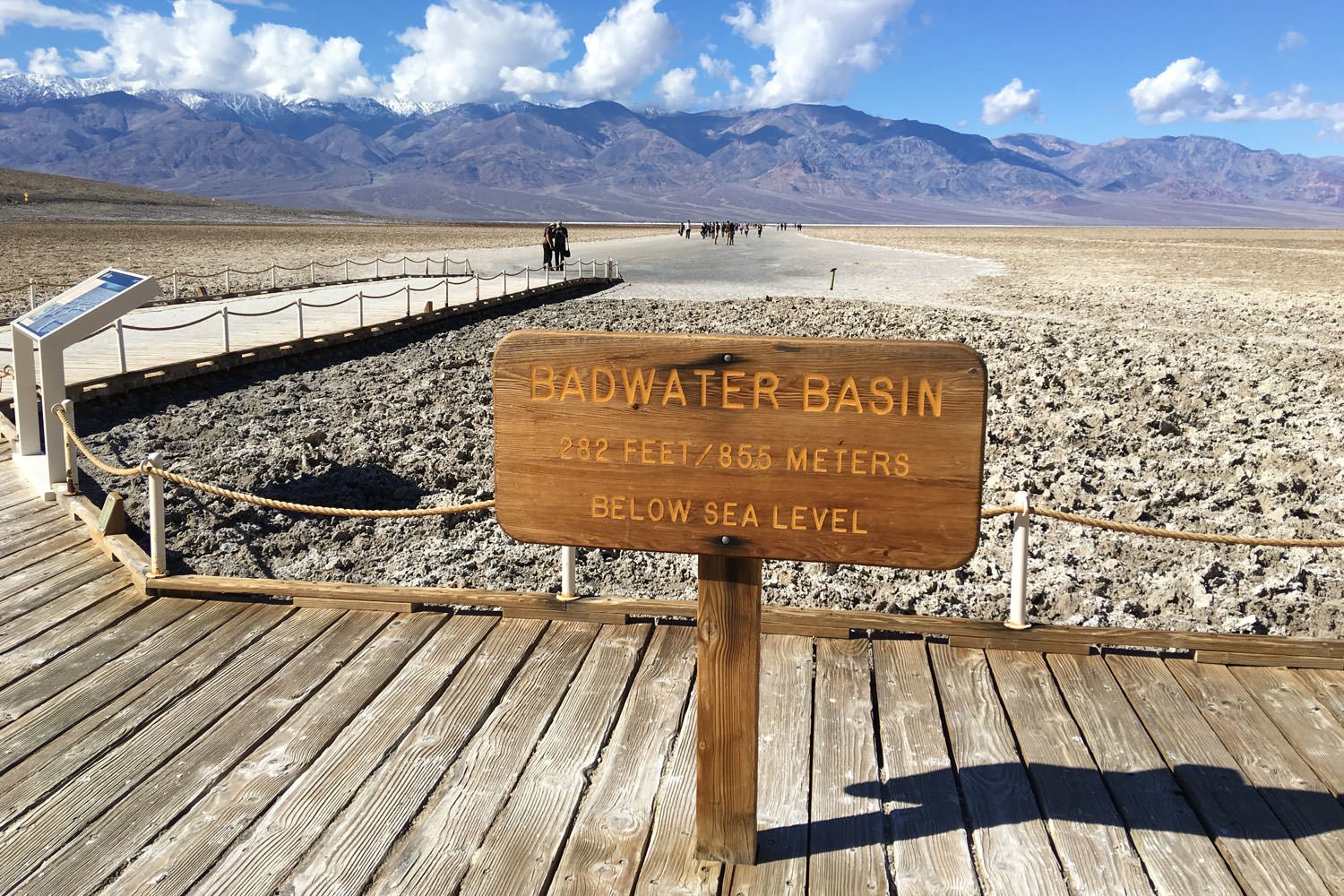
BADWATER BASIN
Death Valley, CA
Beauty can be found almost anywhere if you know where to look. The Badwater Basin in Death Valley is 282 ft below sea level, making it the lowest point in North America, and is entirely void of any foliage, structure, or water (most of the time). However, this unique location can provide great photographic opportunities if you look for them.
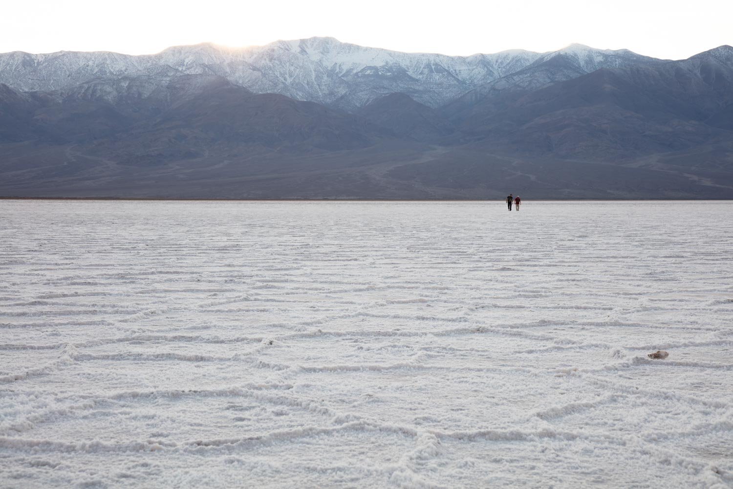
This unworldly salt flat, with endless polygon-shaped formations, is one of the most popular attractions in Death Valley. You would be remiss not to visit this unique experience while visiting the park. This is also home to one of the hottest places on earth.
Images and location summary by Tim Wier
Trail Difficulty - EASY TO MODERATE
I would rate the difficulty of this trail as a 1 - 2 on a scale of 1-5 (with 5 being most difficult). The hike to this location ranges between 1/2 and 1 mile from the parking area (depending on the route you take) with little to no elevation gain.
GPS Coordinates & Elevation
-282 Ft. Elevation
View In Google earth
Download KMZ Trail File
Click Here to download the KMZ file for this location.
Directions
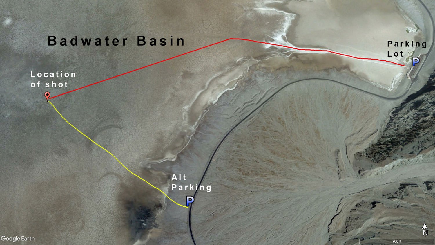
CLICK HERE to get driving directions to the parking area for Badwater Basin
From Furnace Creek - drive east on CA-190 for 1 mile and turn right on Badwater Rd. Travel 16.5 miles to the Badwater Basin parking lot. You can save a 1/2 mile off your hike and avoid a lot of tourists by driving another .8 miles and parking at a pullout on CA-190 past the parking lot (my preference).
Depending on where you park, you will be hiking between 1/2 and 1 mile out to the Badwater Basin and find your favorite composition. The exact spot of the shot above is 36°13'42.3"N 116°47'03.8"W.
Photography Tips
You would think shooting a flat hexagonal-shaped salt pattern would be so simple a caveman could do it. Well, it is not as easy as it looks.
First, you want to decide which direction you will shoot - North or South. The sky, time of year, time of day, clouds, crowds, and weather may impact this decision.
Next, you need to find a suitable series of salt patterns to photograph. There will be thousands of patterns to choose from, but you might want to find a unique lead shape to anchor the image. Choosing the right salt patterns can be impacted by brown mud in the pattern or a broken ridge that will take away from the final image. Take your time, walk all around the basin to find the right pattern for your composition.
The next consideration for your composition is the height of your tripod. Some photographs are shot close to the ground, some are taken as high as possible (with the camera pointing down) and some are composed a foot or two above the salt basin floor. Again, arrive early and test different heights and angles to find the composition that works best for you.
Lastly, you will want to decide where to place the horizon. Do you want to emphasize the salt patterns, or do you want to highlight the distant mountains and sky?
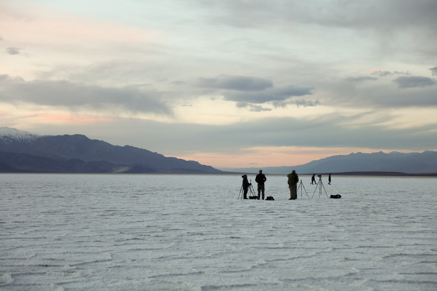
You need to find the right composition long before sunset/sunrise as the mood, hues, and shadows along the ridges of the salt patterns change quickly as the sun moves on the horizon.
The above image was taken facing south, with a 17mm equivalent lens, about 10 minutes after sunset, with the tripod set about 2 ft above the salt basin. I placed the horizon at the top quarter of the image.
EXIF Data
Focal Length – 17 mm
Exposure – 1/5th sec @ f 8.0
ISO – 100
Date – Feb 2nd
Time – 5:28 pm
Best Time of Day to Shoot
Badwater Basin is a great place to visit any time of day. However, for my liking - I was looking for muted tones with shadows on the hexagonal salt rims to give it dimension and depth. With this in mind, I found it best to photograph the salt formations at or after sunset or at or before sunrise.
The traditional shot for Badwater Basis is taken facing either north or south (both are similar shots with “V” shaped mountain ranges shown in the distance). This means you can shoot at either sunrise or sunset. In the winter months, the sun will rise and set facing south - which was the direction of the shot above.
The above image was taken 10 minutes AFTER sunset.
Best Time of Year
I find it is best to shoot locations in Death Valley in the late fall, winter, and early spring months as the temperatures are more moderate (obviously, the summer months are extreme, and I would avoid them). Good weather brings more tourists and photographers, but the area is vast, and the majority of the tourist leave toward sunset and are rarely there at sunrise.
The image above was taken on February 2
Lens(es) Needed
Depending on your composition, you will want to bring a wide or ultra-wide-angle lens. See "nuances of shot" above to help decide which lens is best for you.
The image above was taken with a 17mm equivalent lens.
Birds-Eye View
Permits
Badwater Basin is in Death Valley National Park, and an entrance fee (good for 7 days) is required, $35 - which can be purchased at the visitors' center. Once in the park, there are no other permits required.
Direction of the Shot
The direction of the shot is due south around 180°.
Equipment Needed
From a photography standpoint, make sure you bring a sturdy tripod (for potential multiple exposures or focus stacking) and a good camera bag to store your equipment in. Also, you might want to bring along a GPS devise to mark potential compositions during scouting and/or find your way back to the parking lot after the sun goes down.
Photographing the salt flats at Badwater Basin can be a lot of fun. However, scouting around for the perfect spot, you can walk 2-3 miles. And with a camera bag can take its toll. So obviously plan according to with plenty of liquids, snacks, a hat, sunscreen, and a compass.
Number of Other Photographers to Expect
Badwater Basin is a popular place for tourists and photographers (sometimes in the hundreds on a busy day). However, the salt flats are a fairly large place, and you will just have to find a place that suits you. Crowds are significantly reduced at sunrise and early morning.
Weather
The weather in Death Valley is somewhat modest in the spring and fall, and the winters are pleasant during the days but can dip into the 20s at night. If you are out hiking, it is essential to know that the temperatures can drop dramatically after the sun goes down.
Cell Service
I have Verizon, and there is no cell service at Badwater Basin. The cell service is spotty on the drive back to Furnace Creek - but it is unreliable.
Lodging & Camping
Furnace Creek (18 miles away) is a nice community with lots of rooms/cabins, a campground, a swimming pool, showers, a tennis court, and a golf course. The Oasis at Death Valley is a more upscale resort just 1 mile south of Furnace Creek.
Nearby camping and lodging
Camping - click on the campground below for directions
Texas Springs campground (18 miles)
Sunset campground (18 miles)
Furnace Creek campground (19 miles)
Lodging - click on the lodging below for a TripAdvisor review
The Ranch at Death Valley
(760) 786-2345
328 Greenland Blvd, Death Valley, CA
The Oasis at Death Valley
(800) 236-7916
Furnace Creek, CA
Nearby Restaurants
Fine dining in Death Valley is limited. However, there are several places to eat and a watering hole in Furnace Creek (The Ranch at Death Valley).
There is one restaurant at the Inn at The Ranch at Death Valley and three restaurants at Oasis at Death Valley.
Area Guides and Workshops
None