
Muley Point
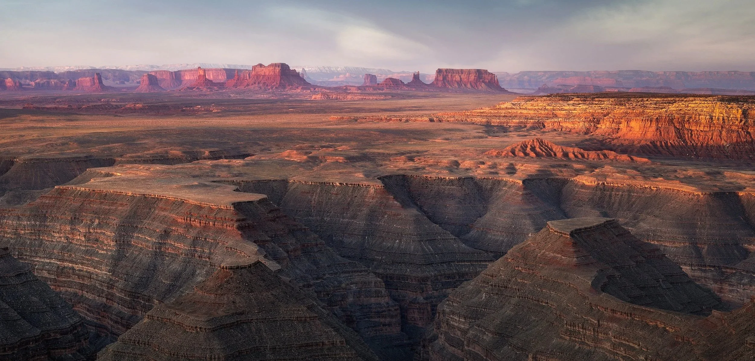
Muley Point
Near Mexican Hat, UT
“And then in the desert, when the sun comes up, I couldn't tell where heaven stopped and the earth began. It's so beautiful" - Forrest Gump
This incredible location, which my friend Gordon Reichard introduced me to, is situated in the southeast corner of Utah, just north of Monument Valley. At sunrise, as the first light of the day illuminates the distant buttes and the red rocks begin to glow, time seems to slow down, and all the worries of the day fade away. You can't help but wonder how this magnificent landscape came to be and what it must have been like in the beginning.
Do yourself a favor and visit this incredible part of the world. The American Southwest never ceases to amaze.
Images and location summary by Tim Wier
Trail Difficulty - MODERATE TO CHALLENGING
The difficulty level of this trail is 2.5 on a scale of 1 to 5, with 5 being the most difficult. The viewpoint is located on the edge of a cliff, providing a stunning view of Monument Valley. To reach this location, you need to hike down a gentle slope from a dirt road that is approximately 300 yards away. If you have a 4x4 vehicle, you may be able to drive closer.
Please note that the dirt road may become impassable if the ground is wet or muddy.
GPS Coordinates & Elevation
6,211 Ft. Elevation
Download KMZ Trail File
Click Here to download the KMZ file for this location.
Photography Tips
This location is absolutely stunning at sunrise, but capturing its essence can be challenging. The Muley Point area stretches 2-3 miles from east to west and offers numerous spots along the road and rim to photograph this breathtaking vista. Each viewpoint overlooking Monument Valley provides a unique perspective.
I chose a spot that highlighted the canyons in the foreground, the red rocks on the right, and the Monument Valley spires in the center. To find the best composition, I recommend arriving the afternoon before and exploring the area to discover which angle you prefer.
For this shot, I decided to create a five-shot vertical panorama and then crop the image to achieve my desired composition. This technique allowed me to capture more detail in both the foreground canyon and the Monument Valley rock formations, which are nearly 15 miles away.
Directions
CLICK HERE to get driving directions to the Muley Point Overlook
From Mexican Hat, drive east on US-163 N for 3.9 miles. Then, turn left onto UT-261 and continue for about 9 miles until you reach the Moki Dugway, which is a winding road with both dirt and paved surfaces. This road leads to the top of the ridge that overlooks the valley and faces Monument Valley.
Once you reach the top of the Moki Dugway, continue for another 300 yards. You'll find a dirt road on your left that leads to Muley Point. Make sure to set your car's odometer at this point. Drive on this dirt road toward Muley Point for 3.8 miles, and you will come to a fork in the road on your left. Take the left dirt road for a quarter of a mile.
From this point, you can either park and hike down to the cliff's edge, or if you have a 4x4 vehicle with high clearance, you can drive down to the cliff's edge.
The Muley Point Overlook stretches 2-3 miles from east to west along this dirt road, allowing you to explore various vantage points by driving up and back.

Moki Dugway


Google Earth
EXIF Data
Focal Length – 94 mm 5 shot vertical pano
Exposure – 1/4 th sec @ f 8.0
ISO – 100
Date – 6:58 am
Time – April 10th
Best Time of Day to Shoot
This location is best photographed during sunrise or sunset. I personally prefer sunrise because it beautifully illuminates the purple rocks of Monument Valley. If you arrive the day before, you can experience both sunset and sunrise.
Best Time of Year
The ideal months for photography at this location are from April to August. In spring, strong winds can stir up dust, which may make capturing clear shots difficult.
Lens(es) Needed
You can use focal lengths ranging from 24 mm to 80 mm at this location, depending on your desired composition. For example, the shot above is a vertical panorama composed of five images taken at 94 mm.
Birds-Eye View From Google Earth Pro


Permits
No permits are required at this location.
Direction of the Shot
The direction of the shot is south by southwest at around 190°.
Equipment Needed
You will want to bring a sturdy tripod (and pano equipment if you take a panoramic shot).
Number of Other Photographers to Expect
This location is popular among RVs, campers, and those looking to spend the night. If you arrive later in the day, you might find it challenging to locate a pull-out or parking area. However, there is plenty of space along the dirt road or you can hike down to the cliff where you can set up your tripod.
Weather
The region around Mexican Hat experiences a high desert climate at an elevation of approximately 6,000 feet. Daily temperatures can fluctuate by 30 to 40 degrees. Spring and fall are generally pleasant, while summer temperatures can soar into the high 90s.
Cell Service
Cell service at Muley Point is spotty.
Area Guides and Workshops
None