
Dead Horse Point

DEAD HORSE POINT
Dead Horse Point State Park, UT
Image by David Long @ www.davelongphoto.com
Dead Horse Point is a must see when visiting the areas around Moab, UT. This iconic viewpoint of this surreal gooseneck in the Colorado River is something you will want to add to your checklist and portfolio.
It is hard to stand on the ledge of this location without wondering how all of this happened. The many layers of sandstone, buttes and vertical cliffs (carved by ice, water and wind) help to create a photographic masterpiece.
This is a great location to spend a day or so hiking, exploring and experiencing this magnificent place – with the added bonus at sunrise and sunset for photographing a masterpiece of your own.
Image by David Long and location summary by Tim Wier
Trail Difficulty - EASY TO DANGEROUS
I would rate the difficulty of this trail as either a 1 or a 3 on a scale of 1-5 (with 5 being most difficult).
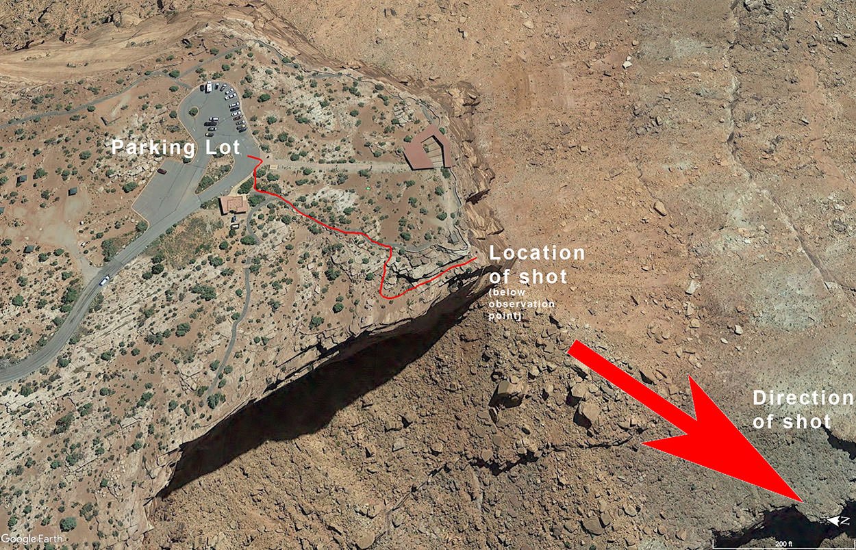
The hike from the parking lot is a moderate 150yd walk (which rates as a 1).
However, if you walk down to the location where this was shot from (which is below the tourist overlook) – you are right on the ledge with a 1,000ft drop. This viewpoint IS NOT FOR EVERYONE and I would rate as a 3.
GPS Coordinates & Elevation
5,944 Ft. Elevation
Download KMZ Trail File
Click Here to download the KMZ file for this location.
Photography Tips
As beautiful as this location is, it can be hard to capture the essence of what you see. I would suggest arriving early and walking up and down the ridge to find your composition. Many photographs I have seen try to anchor the shot with some foreground. There is a famous curved bush about 50-75 yds. along the right side of the ledge from the tourist overlook.
When photographing at SUNRISE the dynamic range between the sky and the valley are extreme and you will most likely have to bracket your exposures. Once the sun crest the horizon, the shot will be blown out very quickly (3-5 minutes) after the sun comes up.
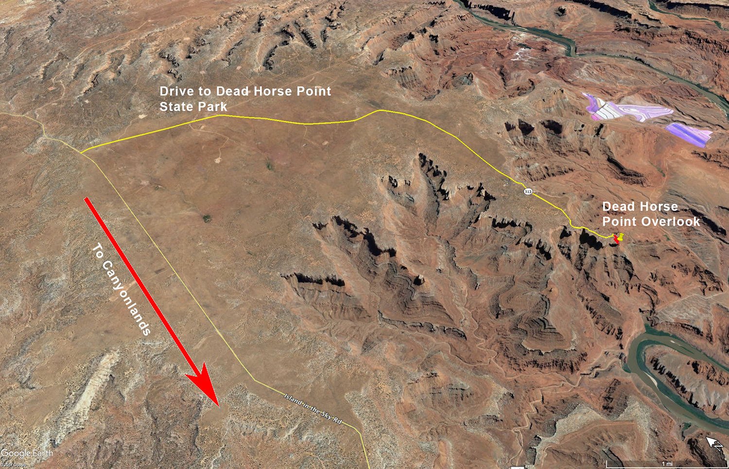
Directions
CLICK HERE to get driving directions to Dead Horse Point
The closest town is Moab, UT (50 miles). The directions are from Moab, UT.
From Moab - travel northwest on US-191for 11 miles until you reach the entrance to the Canyonlands National Park. Take a left on UT-313 and drive west and then south 14.6 miles until you see the sign for Dead Horse Point State Park. Continue for the next 8.0 miles until you reach the parking lot.
From the parking lot follow the cement sidewalk to the covered visitor’s area and then turn right to the visitors overlook. The shot above was taken directly below the visitors overlook. To get to this point you need to walk down the asphalt walkway for 50 yds or so and hike down to an undeveloped trail along the ledge. The drop-off from the ledge is 1,000ft and certain death. Extreme caution is called for in this location.
Google Earth
EXIF Data
Focal Length – 24 mm
Exposure – 1/4 sec @ f 8.0
ISO – 100
Date – Aug 19th
Time – 6:48 am
Best Time of Day to Shoot
Even though Dead Horse Point can be photographed at either sunset or sunrise, I much prefer sunrise. However, I would suggest doing both if possible. For sunset, the long shadows and glowing red rock come from the right to left. At sunrise, the sun comes from the left. The shot above was taken at sunrise.
I would also suggest shooting at both 30 minutes or so before sunrise and after sunset as the light can be interesting during these periods.
Best Time of Year
Dead Horse Point can be photographed any time of the year. However, clouds and interesting weather help to produce a better image, so I like to go during the late summer months (monsoon season) as to have a better chance for clouds and weather.
Lens(es) Needed
This shot can work so many ways: a pano, a tight compression or a nice wide-angle vista. Bring lenses ranging from 16 – 135mm. The above shot was taken with a 24mm lens.
Birds-Eye View From Google Earth Pro
Permits
Dead Horse Point is a state park and the fee at time of this writing is $15 per vehicle up to eight passengers, valid for 3 days, $10 for seniors 62 and older, $10 per motorcycle, $2 pedestrian or cyclist (biking into park).
Direction of the Shot
There are tons of different compositions at Dead Horse Point. The majority of the time you will be shooting south around @ 200°
Equipment Needed
No need for any special photography equipment (other than a sturdy tripod and a polarizer) unless you plan on doing a panoramic shot. You may also want to consider using a tilt/shift lens if you have one to compensate for the keystone effect while pointing down toward river.
Number of Other Photographers to Expect
Dead Horse Point can be very busy during the tourist season and there will most likely be many photographers along the ledge for SUNSET around the tourist overlook. Fewer photographers get up for SUNRISE, but there are only a few premium locations – so make sure you get there early to claim your place.
Weather
Dead Horse Point is a high desert climate where temperatures can vary up to 40° in a day. Spring and fall are nice, but summer can get into the 100s. The monsoon season (in late summer) brings violent but brief thunderstorms, which often cause flash floods.
Cell Service
I have Verizon and there is no cell service from this location.
Lodging & Camping
The Dead Horse State Park is about 35 miles from Moab, on the road to Canyonlands National Park. Moab is a nice town and has an abundance of lodging.
There are 2 nice campsites in the Dead Horse State Park and a few other campsites in and around Canyonlands National Park. Inside the state park are: 1) Kayenta campground with 21 sites (17 standard partial hookups and 3 yurt) and 2) Wingate Campground with 31 Sites (20 RV & Tent & 11 Hike-In Tent Only). Nearby camping and lodging
Camping - click on the campground below for directions
Kayenta Campground - (In Dead Horse Point State Park)
Wingate Campground - (In Dead Horse Point State Park)
Horsethief Campsite (10 miles north back toward Moab)
Willow Flat Campground (17 miles south by the Green River Overlook)
Cowboy Campsite (8 miles north back toward Moab)
Lodging - click on the lodging below for a TripAdvisor review
Red Cliffs Lodge
(435) 259-2002
Mile Post 14 Hwy 128, Moab, UT
INCA Inn and Motel
(435) 259-7261
570 N Main St, Moab, UT
Gonzo Inn
(435) 259-2515
100 W 200 S, Moab, UT
Nearby Restaurants
There are no restaurants or lodges in the Dead Horse State Park. Moab, UT, is the nearest town (35 miles) and has a nice choice of restaurants. There are several good places to eat in Moab. Eklecticafé is a nice place for breakfast and the Desert Bistro is a high-end place for dinner.
Nearby Restaurants - click on the restaurant below for yelp review
Desert Bistro
(435) 259-0756
36 S 100 W, Moab, UT
Twisted Sista's Cafe
(435) 355-0088
11 E 100 N, Moab, UT
Area Guides and Workshops
None