
Marlboro Point

A Light Dusting
Near Moab, UT
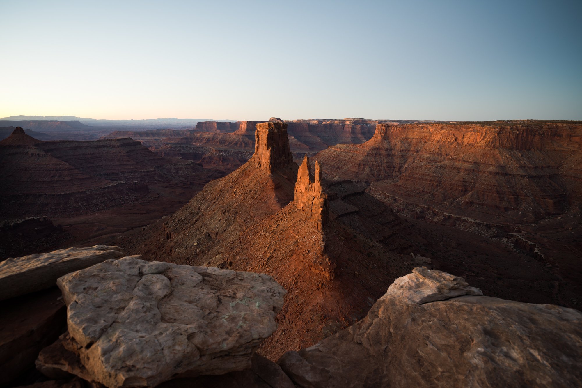
An old college buddy used to say, "I would rather be lucky than good." Being at this magical place, on this particular day - I would agree. Trips to this location are not easy, and being here at sunrise following a perfect dusting of snow was just plain lucky.
Marlboro Point is one of the iconic vistas in the American Southwest. This wonderful place can be photographed at either sunrise or sunset. And when it snows, it transforms into one of the most beautiful places anywhere. Standing on the cliffs overseeing this fantastic scene, you find yourself wondering - How Did This Happen?
A little story to remind you that this location is in the middle of nowhere - a good friend recently visited Marlboro Point on a morning just like what you see above. It had snowed 3 - 4" the night before, and he wanted to get a shot with snow in the canyon. He was alone and didn't have a 4x4 vehicle, so he had to walk 2+ miles at 5 am (in pitch darkness) to get there for sunrise. After sunrise, another couple showed up to witness the beautiful scene. After chatting a bit, they asked where his dog was as they saw large paw tracks in the snow following him all the way to Marlboro Point.
My friend was stunned and silent for a moment - and then let the couple know that he didn't have a dog!
Images and location summary by Tim Wier
Trail Difficulty - CHALLENGING TO DIFFICULT
I would rate the difficulty of this trail as a 4 on a scale of 1-5 (with 5 being the most difficult).
It is not an easy location to get to and is not for everyone. The hike can be either short or long, depending on your vehicle and off-road abilities.
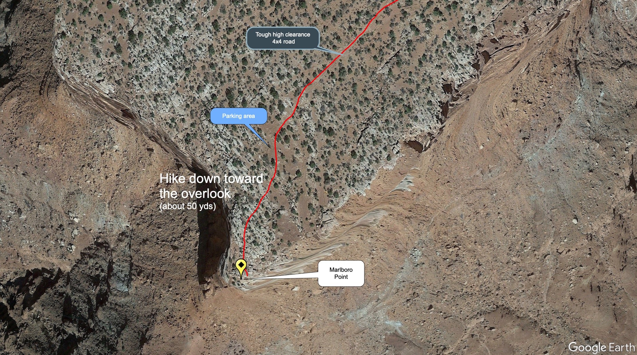
The road(s) to Marlboro Point start out simple and progressively get more difficult as you get closer to the lookout. Ultimately, the road can get you to within 50 yards of the overlook. However, the last mile is high clearance 4 x 4 vehicle only, and the last part is downright rough. With that in mind, there are multiple places to stop and park (based on your comfort zone) along the way.
I have a high clearance 4 x 4 vehicle and have decent off-road skills. I usually stop about a half mile from the overlook and walk the rest of the way. My friend Gordon (the goat) can easily drive all the way to the end while eating a sandwich and reading poetry. It is just a matter of perspective.
GPS Coordinates & Elevation
5,867 ft Elevation
Download KMZ Trail File
Click Here to download the KMZ file for this location.
Photography Tips
This is not a location to just walk up and take a picture. This majestic place offers so many different ways to capture the scene. You will want to arrive early to walk around and study the different angles and compositions. I have visited Marlboro Point at sunrise and sunset, and both offer great composition opportunities.
For sunrise - I prefer to shoot during the blue hour (10 - 30 minutes before sunrise). This time provides a pastel scene with the sun's reflective light painting the monuments.
Also, just after sunrise, as the first light illuminates the back canyon walls and monuments, you can capture a nice image.
Finally, in the winter months, about 20-30 minutes after sunrise, the scene transforms into a spaceship (see below). It is not a great shot, but in some ways appealing.
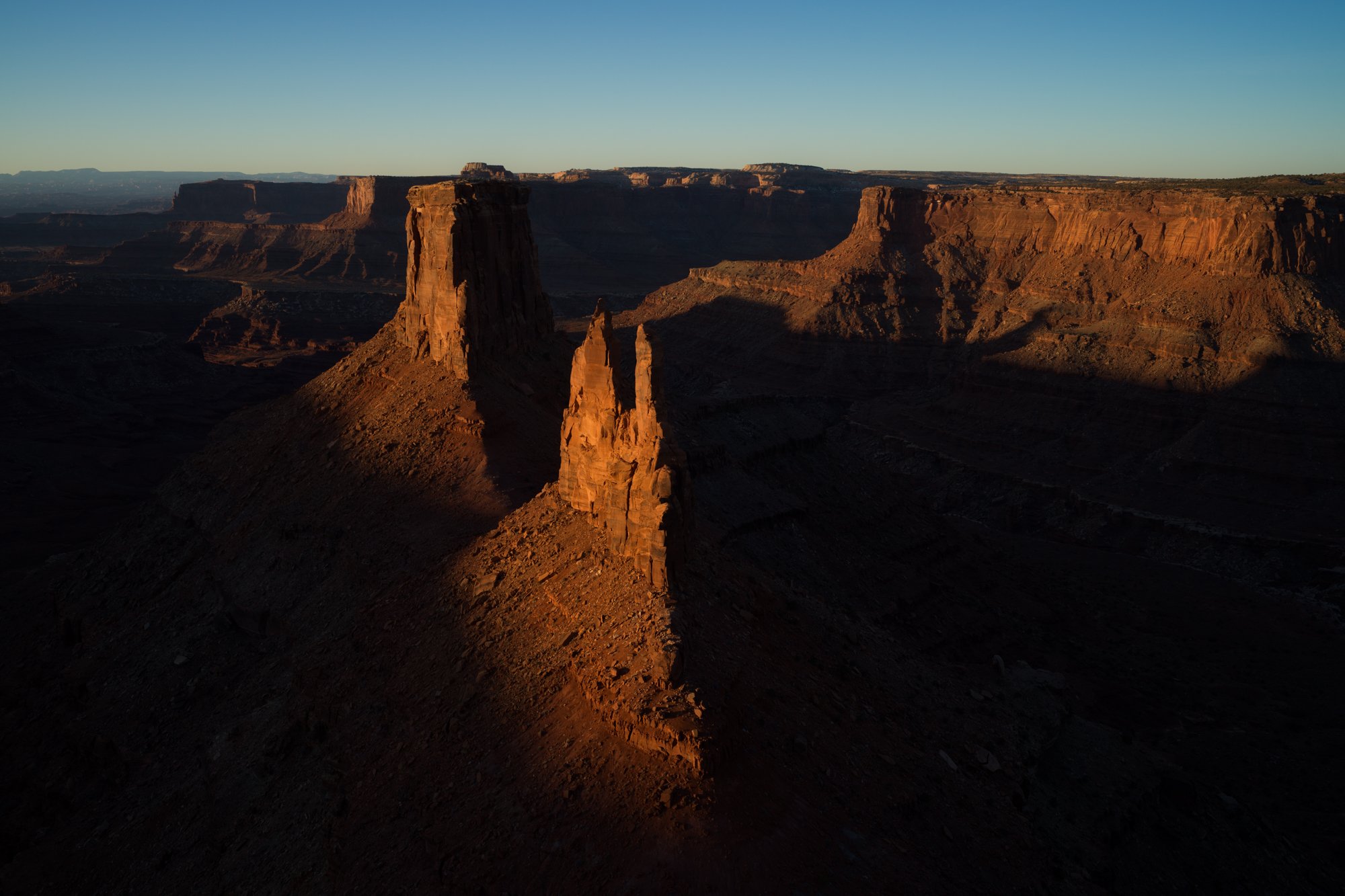
For sunset - if you arrive in the late afternoon, you can photograph the scene with the sun's last light illuminating the Marlboro Point spires (this is hard to do as the dynamic range is extreme). Another option is to wait several minutes after sunset as the reflective light illuminates the spires and creates separation from the rest of the scene.
Directions
CLICK HERE to get driving directions to Marlboro Point
SPECIAL NOTE when using mapping apps to this location - the mapping systems may direct you in several different ways to Marlboro Point. The dirt road holds different challenges depending on your approach.
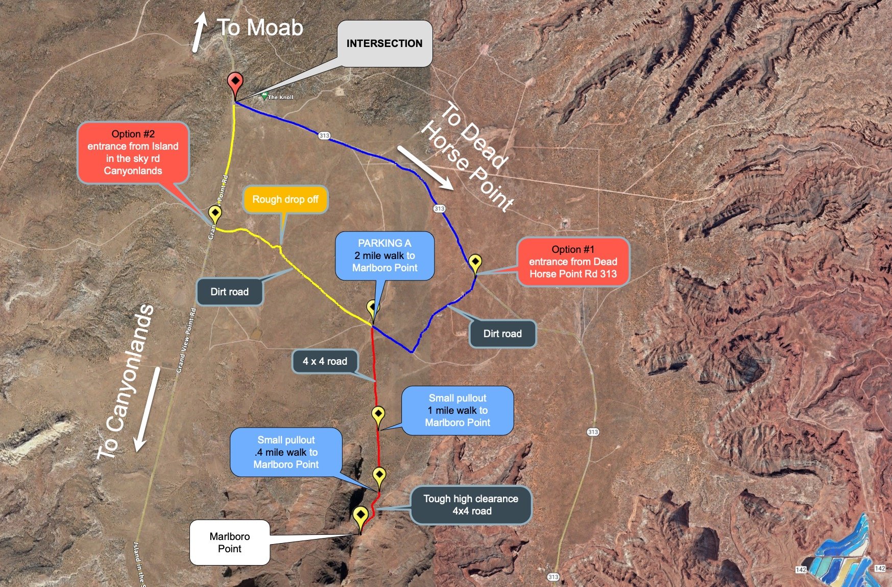
From Moab - drive north on US 191 for 11 miles until you come to the turnoff for Canyonland NP. Turn left onto UT 313 (toward Canyonland NP and Dead Horse Point SP) and drive for 14.5 miles until you come to an intersection that takes you to either Canyonland NP (straight) or Dead Horse State Park (left). This point is labeled INTERSECTION on the map below. From the intersection, there are two options to get you to Marlboro Point.
Option #1 (shown in blue) - at the intersection, take a left on UT 313 toward Death Horse Point SP for 3 miles until you come to a dirt road on the right. Take this road for about 1 mile until you reach another perpendicular dirt road. At this dirt road, take a right and drive for about .4 of a mile. This will bring you to a little parking area 38°31’21.6”N 109°46’05.4”W listed as Parking A on the map below.
Option #2 (shown in yellow) - at the intersection, continue straight on Island in the Sky/Grand View Point road (toward Canyonlands NP) for 1.1 miles until you come to a dirt road on the left. Take this dirt road for 1.8 miles. This will bring you to the same parking area listed in Option #1.
From the Parking A location - the drive/walk is about 2 miles south to the Marlboro Point overlook. If you are driving further, this sandy road gets progressively more difficult and downright rough toward the end. There are a few pullout areas along the way (see map below).
Once you get to the overlook, walk down the ridge and find your composition.
View In Google Earth
EXIF Data
Focal Length – 17 mm
Exposure – 6 sec @ f 8.0
ISO – 100
Date – Feb 17th
Time – 6:47 am
Best Time of Day to Shoot
This location can be taken at either sunrise or sunset (I prefer sunrise) and intermittent moments after or during a storm. Some of the best images I have seen, or taken during the day, when radiant light spilled out on the canyon.
For sunrise, my preference is to shoot during the blue hour (10 - 30 minutes before sunrise). Once the sun reaches the back wall and the Marlboro Point spires, the scene appears very different. And after the sun works its way down to the canyon floor, the moment is blown out.
For sunset, don't waste your shots in the afternoon as the scene is too harsh - it is best to wait until the sun approaches the horizon. The indirect sun (at either sunrise or sunset) will illuminate the Marlboro Point spires to get a great shot.
Best Time of Year
This location can be photographed at any time of year. However, there are good times and there are better times.
Winter can be very cold but can produce snow. During winter, the sunrise will be from the left front and the sunset from the right front. This can be a great time to visit Marlboro Point.
During the fall and spring months, the sunrise is 90° to the left, and the sunset is 90° to the right of the shot. This is also a great time to visit this location.
In the summer, the temperatures are hot, and the sunrise is behind you. The sunset is to the right back.
The image above was taken on Feb 17th
Lens(es) Needed
You can shoot this fantastic location in many different ways. Consider bringing lenses ranging from 16mm to 105mm. I shot the image above with a 17mm equivalent lens.
Birds-Eye View From Google Earth Pro
Permits
There are no permits required in the area.
Direction of the Shot
The direction of the shot is south@ around 170 - 200°.
Equipment Needed
No need for any special photography equipment (other than a sturdy tripod and a polarizer) unless you plan on doing a panoramic shot. Consider using a tilt/shift lens if you have one to compensate for the keystone effect while pointing down toward the canyon.
Number of Other Photographers to Expect
This location is off the beaten path and is pretty dang hard to get to. I have only seen a few other folks there when I have been to Marlboro Point.
Weather
Marlboro Point is a high desert climate where temperatures can vary up to 40° in a day. Spring and fall are nice, but summer can get into the 100s. The monsoon season (in late summer) brings violent but brief thunderstorms, which often cause flash floods.
Cell Service
I use Verizon, and there is LIMITED cell service at this location. Cell service is spotty and is not a strong signal until you get back to Moab.
Lodging & Camping
Marlboro Point is between the Dead Horse Point State Park and Canyonlands National Park, and the nearest town is Moab (27 miles). Moab is a nice town and has an abundance of lodging.
The closest campsite to Marlboro Point is the Horsethief Campground. There are also campsites at the Dead Horse State Park. The Dead Horse campground has 20 sites (17 standard partial hookups and three yurts). Sites are $15 per night.
Nearby camping and lodging
Camping - click on the campground below for directions
Willow Flat Campground
Kayenta Campground
Horsethief Campsite
Cowboy Campsite
Lodging - click on the lodging below for a TripAdvisor review
Red Cliffs Lodge
(435) 259-2002
Mile Post 14 Hwy 128, Moab, UT
INCA Inn and Motel
(435) 259-7261
570 N Main St, Moab, UT
Gonzo Inn
(435) 259-2515
100 W 200 S, Moab, UT
Nearby Restaurants
There are no restaurants near Marlboro Point. Moab, UT, is the nearest town (27 miles) and has a nice choice of restaurants. There are several good places to eat in Moab.
Nearby Restaurants - click on the restaurant below for yelp review
Desert Bistro
(435) 259-0756
36 S 100 W, Moab, UT
Twisted Sista's Cafe
(435) 355-0088
11 E 100 N, Moab, UT
Area Guides and Workshops
None