
Sandwich Boardwalk
Sandwich, MA
SANDWICH BOARDWALK
A BRIEF SUMMARY OF SANDWICH BOARDWALK
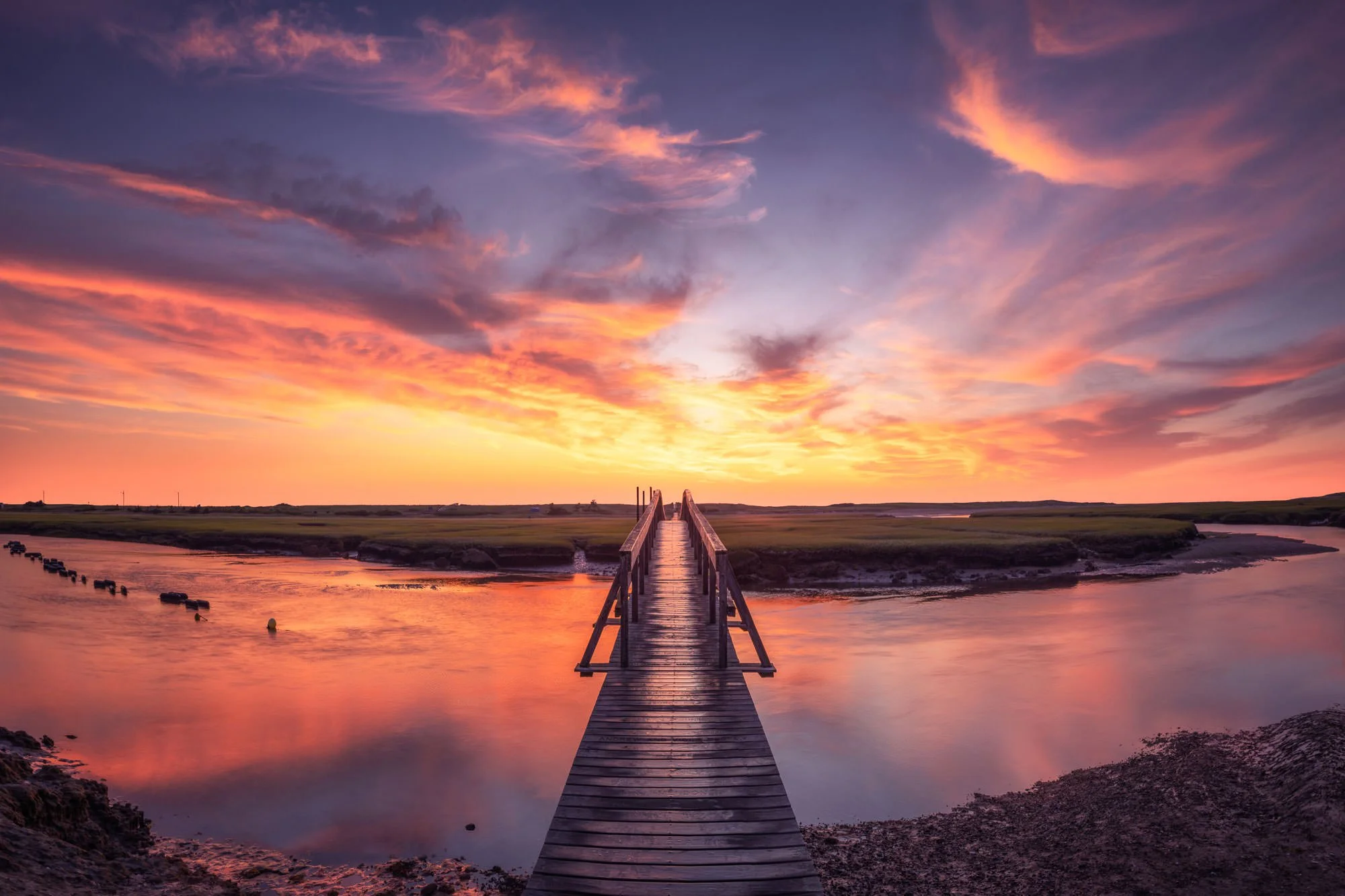
This wonderful location is just a few miles from the Cape Cod Canal. The Sandwich Boardwalk is a 1,350 ft long wooden boardwalk that spans across a creek and marsh ending at Town Neck Beach in Sandwich.
Originally built in 1875 it has been rebuilt numerous times due to damage from various storms. Many of the wooden planks that make up the boardwalk are engraved with donor names/messages. The boardwalk, creek and surrounding marsh create ideal leading lines, and offer many compositional opportunities. While an enjoyable place to go for a walk anytime, I would consider this primarily a sunrise location and looks best with colorful clouds reflecting in the bodies of water.
Photos and location summary by Matt Reynolds

Annual Subscription
Lifetime Membership
DATA POINTS INCLUDED WITH SANDWICH BOARDWALK SUMMARY
I would rate the difficulty of this trail a 1-2 on a scale of 1-5 (with 5 being most difficult). It doesn’t get much easier in terms of access or difficulty rating. The boardwalk starts at a parking lot and you can be out of your car and shooting in a matter of minutes. Getting muddy is about the worst-case scenario, though it is imperative that you check the tide times before venturing out as the tides move in fast. While the physical danger is quite low, the chance of getting your gear wet is real. Marsh mud is also very slippery when wet.
Most of the marsh and surrounding area can be walked on, but at the end of the trail please stay on the boardwalk as it climbs the beach dunes. Those sand dunes are protected and no access is permitted.
Please respect all postage signage in the area.
I mentioned above, the seasonal aspects, camera settings, choice of lens, etc…
I have not yet mentioned the importance of tidal conditions in regard to potential imagery. A higher tide will generally be optimal as the marsh areas look best when filled with water. The “shoulder season” time of year brings more importance to higher tides. While my preference would be for high tide, colorful clouds is more important than the tide (all of the images above were taken near low tide). I do think each of the presented images could look better in the same conditions but at high tide. Also, a still morning (not much wind) will aid in the stillness of the water in the creek and marsh areas, which does help with reflections.
The tidal differences can bring significant landscape changes to any location on the bayside of Cape Cod and I always recommend checking Cape Cod Tide Chart before you go.
While not important to photography, low tide can bring an odor which some may find unpleasant and venturing into the muddy areas can bring that smell to your clothing as well.
There are quite a few locations that work for photography at this location. You can shoot from either side of the marsh, or on the boardwalk. I would let the conditions and direction of the sun decide which is best on location.
Images #1 & #4 were taken on the boardwalk, while images #2 and #3 were taken standing in the very muddy marsh.
With the close proximity to the parking lot and relatively small area, you can get away with coming here before sunrise and finding a composition, without prior location scouting.
This location is primarily a wide-angle or normal focal length spot. The boardwalk or marsh can be used to create a nice foreground which can be emphasized with a wide-angle lens.
The main image above was a 6 shot vertical pano (each taken @ 21mm prime lens) - full frame camera, f11, and 1 second to smooth out the water and bring out optimal reflections. I used a circular polarizer and a 3 stop ND filter and the image was taken about 10 minutes before sunrise. My objective was to capture the curve of the water in the creek which is why I opted for the pano.
Sea Level Ft. Elevation
Other Resources Available with Membership
Detailed Directions
Best Time of Day to Shoot
Best Time of Year to Shoot
Equipment Needed
Required Permits
KMZ Trail File
Direction of Shot
Google Maps Birds-Eye-View
Number of Photographers to Expect
Cell Service
Current Weather
Lodging & Camping
Area Guides and Workshops
Other Resources
LOCATION SUMMARIES WRITTEN BY PROFESSIONAL PHOTOGRAPHERS


