
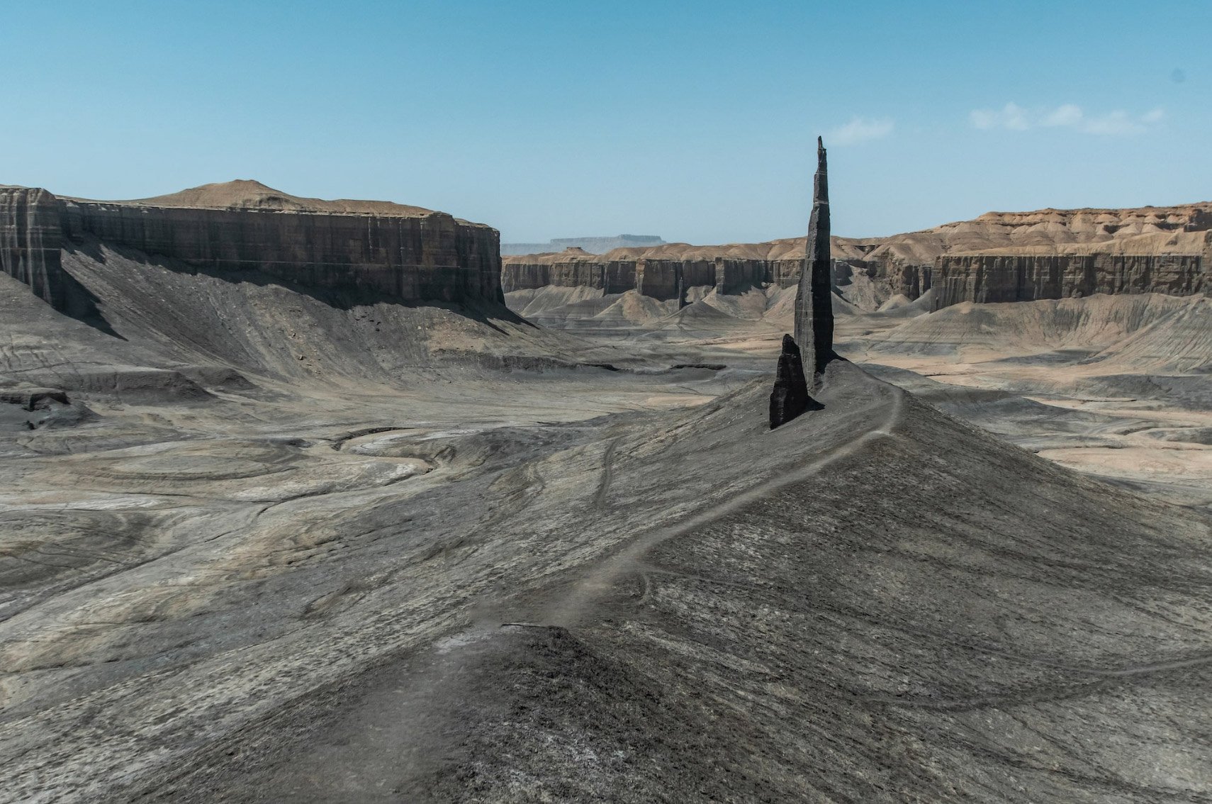
The Spire

The SPIre
Near Hanksville, UT
Image by Rob Strain @ www.robstrain.com
This once-hidden location is one of the most intriguing formations in the American Southwest. It invokes mystery and a sense of disbelief that this place exists. I can assure you that this place does exist, just as you see it in the image above (except for the hundreds of footprints and trails leading up to the spine).
For many years, I purposely did not include this location on our website because of the fragile nature of the loose dirt surrounding the area and the spine up to The Spire. However, this location has become the worst-kept secret in this area and is easily found on Google Maps/earth or in numerous YouTube videos. I decided to include the location, hoping visitors would better understand the fragile scene and how to protect it best when visiting.
LEAVE NO TRACE principles are fundamental at this amazing place. The location and surrounding areas are fragile, so please take additional precautions to avoid ruining them. Doing your part to keep this location beautiful includes - DO NOT DRIVE PAST THE BLM POST, and when hiking to The SPIRE, stay wide of the formation and ONLY WALK UP FROM THE FAR LEFT SIDE.
Location summary by Tim Wier
Trail Difficulty - MODERATE
I would rate this trail's difficulty as 2.5 on a scale of 1-5 (with 5 being the most difficult).
Access to this location changes from time to time. Currently, there is a sign that restricts driving up to the location. It is a moderate hike of about a mile from the designated parking area. The last section has some elevation gain, and the dirt is very loose and can be exhausting. You will see several footpaths up to The Spire on the front and right sides. PLEASE STAY TO THE LEFT (by the ridge) when walking up the shot's location to help reduce the footprints.
IMPORTANT: The image above doesn't exist anymore as it is shown - because the area up to and around The Spire has been trampled by footprints and vehicles driving up to the base of the formation. Please do your best to preserve this unique place in the American Southwest.
GPS Coordinates & Elevation
5,411 Ft. Elevation
Download KMZ Trail File
Click Here to download the KMZ file for this location.
Photography Tips
I am sad to report that this wonderful location is extremely challenging to photograph anymore (without hours of tedious cloning and stamping) - because the area up to and around The Spire has been trampled by foot traffic and vehicles.
Photographing this scene is pretty straightforward after you have hiked to the location of the shot. Once on the spine behind The Spire, you might want to walk around and try the best composition, but remember that you will create more footprints in your shot.
The best photographs of this location are taken with the sun to the right of the Spire in the late afternoon. This time of day provides strong light and deep shadows, creating the perfect mood for this unworldly scene. This only happens in the late spring, summer, and early fall when the sun sets in the northwest (see the image below, which displays the direction of the sunrise and sunset at different times of the year). At other times of the year, the sun sets to the left or directly in front of The Spire. Sunrise is an option (but a poor one) as there is a very tall ridge behind The Spire, and by the time the sun crests the ridge, this shot is washed out.

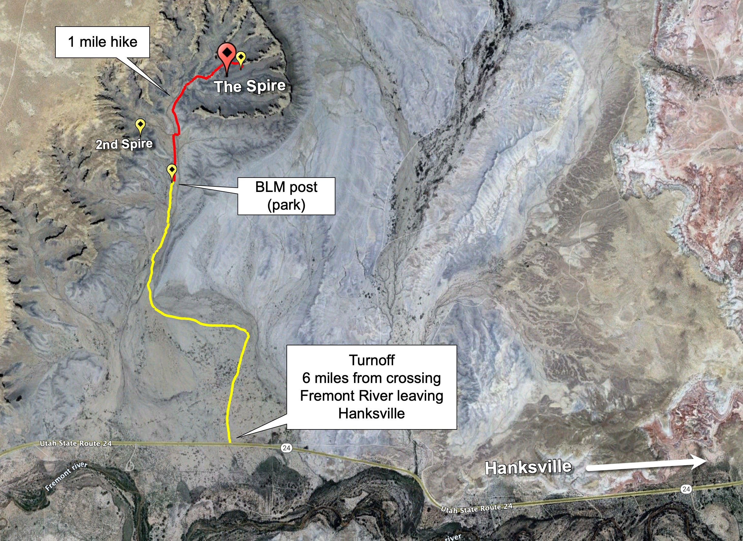
Directions
From Hanksville, drive west on UT-24 out of town. Once you cross over the Fremont River (leaving Hanksville), drive for 6.0 miles, and you will see an open field to your right. At this point, you will see an easy-to-miss turnoff onto an unmarked and unmaintained dirt vehicle path/road heading north.

Follow the vehicle tracks on the dirt road for .5 miles, where you will come to a fork - with tracks continuing north (straight) and turning west (left). Follow the track west (left) for .5 miles, and the vehicle tracks will then turn north (right). Follow the track north for about .5 mile, and you should come to a BLM post that restricts driving further.
Follow the vehicle tracks on the dirt road for .5 miles, where you will come to a fork - with tracks continuing north (straight) and turning west (left). Follow the track west (left) for .5 miles, and the vehicle tracks will then turn north (right). Follow the track north for about .5 miles, and you should come to a BLM post restricting driving further.
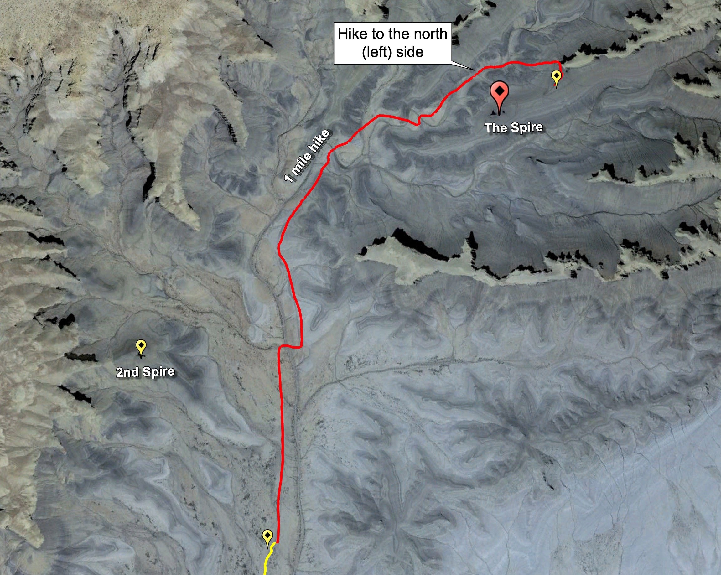
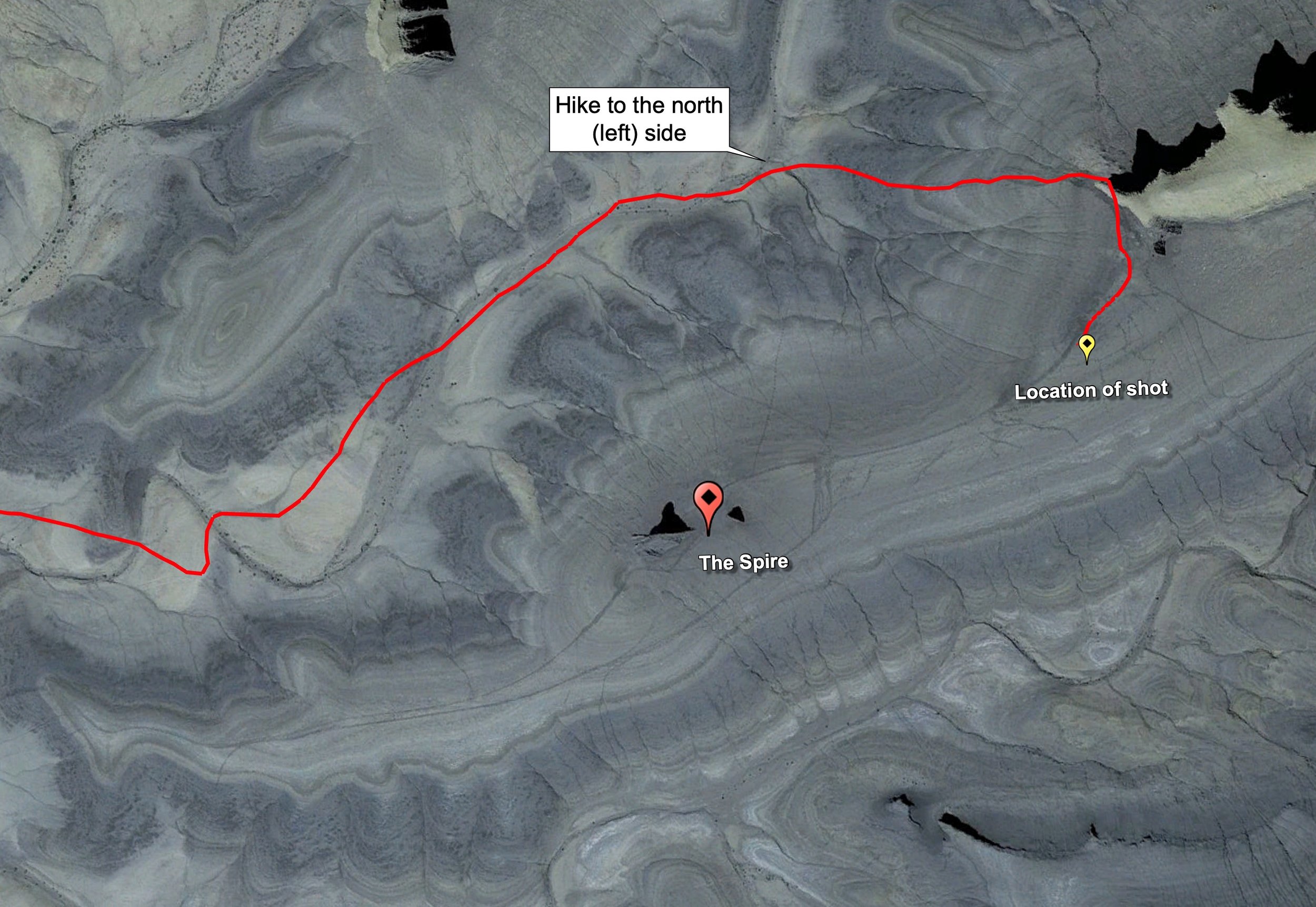
From the BLM post, continue walking north for about .5 miles, and you will see the 2nd Spire to your left against the ridge line. THIS IS NOT The Spire shown above. Just keep walking through the wide opening of the tall ridges, and you will see The Spire to your right. IT IS BEST TO WALK AROUND TO THE LEFT OF THE SPIRE TO reduce the footprints. The location of the shot is on a ridge spine above (northeast) The Spire.
IMPORTANT:
When driving to The Spire, you may be tempted to drive past the BLM post and save yourself half a mile or so of walking. However, parking beyond the BLM post will result in a hefty fine from a passing Ranger.
If the open field off UT-24 is wet (recent rain or snow), DO NOT ATTEMPT driving or walking to The Spire. I don't care if you drive a vehicle with 42" x 15" tires or a Sherman tank - you will get stuck.
Google Earth
Best Time of Day to Shoot
This location is best photographed in the late afternoon. Pay attention to the right side of the spine, leading from the location of the shot to The Spire. You will want to photograph this BEFORE this area goes into shadow.
Other options include:
Toward sunset - when the area around the Spier and canyon is no longer covered in sunlight, the sky behind the scene is colorfully illuminated.
Blue or golden hour is when the light is flat, and the sky can be colorful. Extra processing is needed to make this hour pop.
Sunrise is an option (but a poor one) as there is a very tall ridge behind The Spire, and by the time the sun crests the ridge, this shot is washed out.
Best Time of Year
The best time to photograph this location is in late spring, summer, and early fall when the sun sets in the northwest (see the image above, which displays the direction of the sunrise and sunset at different times of the year). At other times of the year, the sun sets to the left or directly in front of The Spire.
Lens(es) Needed
You will want to bring lenses ranging from 24 mm to 50 mm. The image above was taken around 35mm.
Birds-Eye View From Google Earth Pro
Permits
No permits are required in the area.
Direction of the Shot
The direction of the shot is southwest, around 250°.
Equipment Needed
From a photography standpoint, you need a sturdy tripod and potentially a lens hood to protect against lens flare. If shooting late in the afternoon, you may be hiking back to your vehicle in the dark, so bring a flashlight or a headlamp.
Number of Other Photographers to Expect
This location is off the beaten path and is hard to get to. However, it is a spectacular place, and you may see other people there.
Weather
The area around Hanksville has a high desert climate at about 5,000 ft. elevation. Temperatures can vary up to 30° —40° a day. Spring and fall are nice, but summer can get into the high 90s.
Cell Service
I have Verizon, and the cell service from this location is spotty. A stronger cell signal is available as you are near Hanksville.
Lodging & Camping
The area around the Factory Butte is badlands, with the closest towns being Hanksville and Caineville, Utah. There is a small camping area just off of the road to this location (not sure if it is sanctioned by BLM or not) with a makeshift fire pit. There are other camping areas and lodgings in both Hanksville and Caineville. There are 2 motels and 2 RV Parks in Hanksville and 1 hotel in Caineville.
Camping - click on the campground below for directions
Duke's Slickrock Campground & RV Park – 275 E Highway 24, Hanksville, UT 84734
Lodging - click on the lodging below for a TripAdvisor review
Muddy Creek Mining Company
(877) 711-3857
280 E 100 N, Hanksville, UT
Whispering Sands Motel
(435) 542-3238
90 South HW 95, UT
Nearby Restaurants
Hanksville is the closest town, and there are a few places to eat there. After a morning shoot, I enjoy a good breakfast (biscuits and gravy) at Duke's Slickrock Grill in Hanksville. They have great food, and nice people run the place. Stan's Burger Shak makes a good hamburger and a hardy shake, and the Outlaw's Roost makes great tacos.
Nearby Restaurants - click on the restaurant below for yelp review
Duke’s Slickrock Grill
(435) 542-3235
Stan's Burger Shak
(435) 542-3330
Outlaw’s Roost
(435) 542-1763
Area Guides and Workshops
None