
Lake Maurepas

LAKE MAUREPAS
Near New Orleans, LA
Image by Rick Berk @ www.rickberk.com
The Louisiana Bayou is not a place that quickly comes to mind when thinking of photogenic locations for landscape photography. But oh how wrong you'd be! Lake Maurepas is a challenging, but fun, landscape photo location. Tall cypresses grow out of the water, draped in Spanish moss, catching the southeastern sunlight as the sun rises or sets. It can be magical.
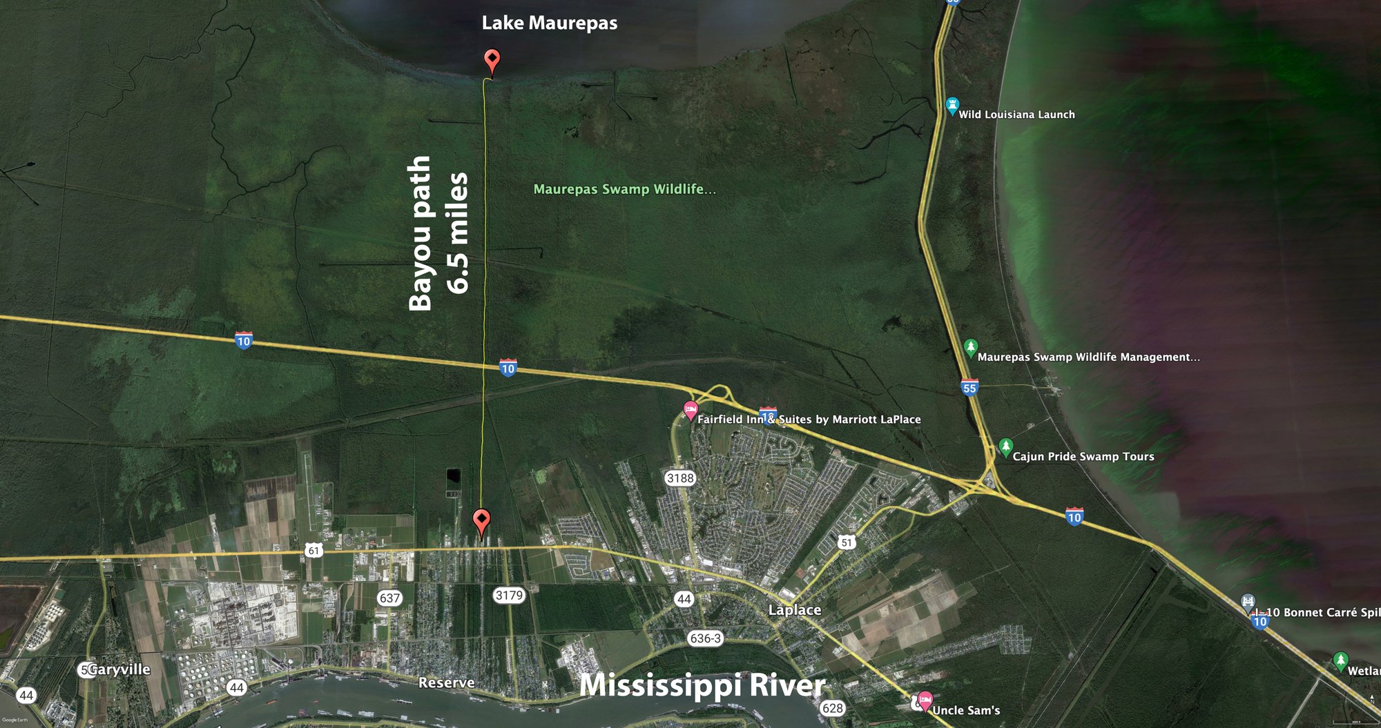
Lake Maurepas is round, shallow, brackish lake located just west of Interstate highway 55 and Lake Pontchartrain, and just north of Interstate 10 in southeastern Louisiana. The lake is fed by four rivers, the Blind River, Amite River, Tickfaw River, and Natalbany River. The south shore of Lake Maurepas, where "Cypress Symmetry" was taken, is part of the Maurepas Swamp Wildlife Management Area. The average depth of the lake is approximately 10 feet and the surface area is approximately 93 square miles.
Lake Maurepas features all of the typical swamp wildlife you would expect, including osprey, alligators, wood ducks, loons, deer, rabbits, and more. It's as much a wildlife photographer's dream as it is a landscape photographer's dream. The one catch is that access to the lake is by boat, canoe, or kayak only. There are no foot trails directly lakeside. There is a short, one-mile trail in the Maurepas Swamp Wildlife Management Area, but that does not take you past the lake, nor does it give you access to the gorgeous cypresses.
Photos and location summary by Rick Berk
Trail Difficulty - DIFFICULT
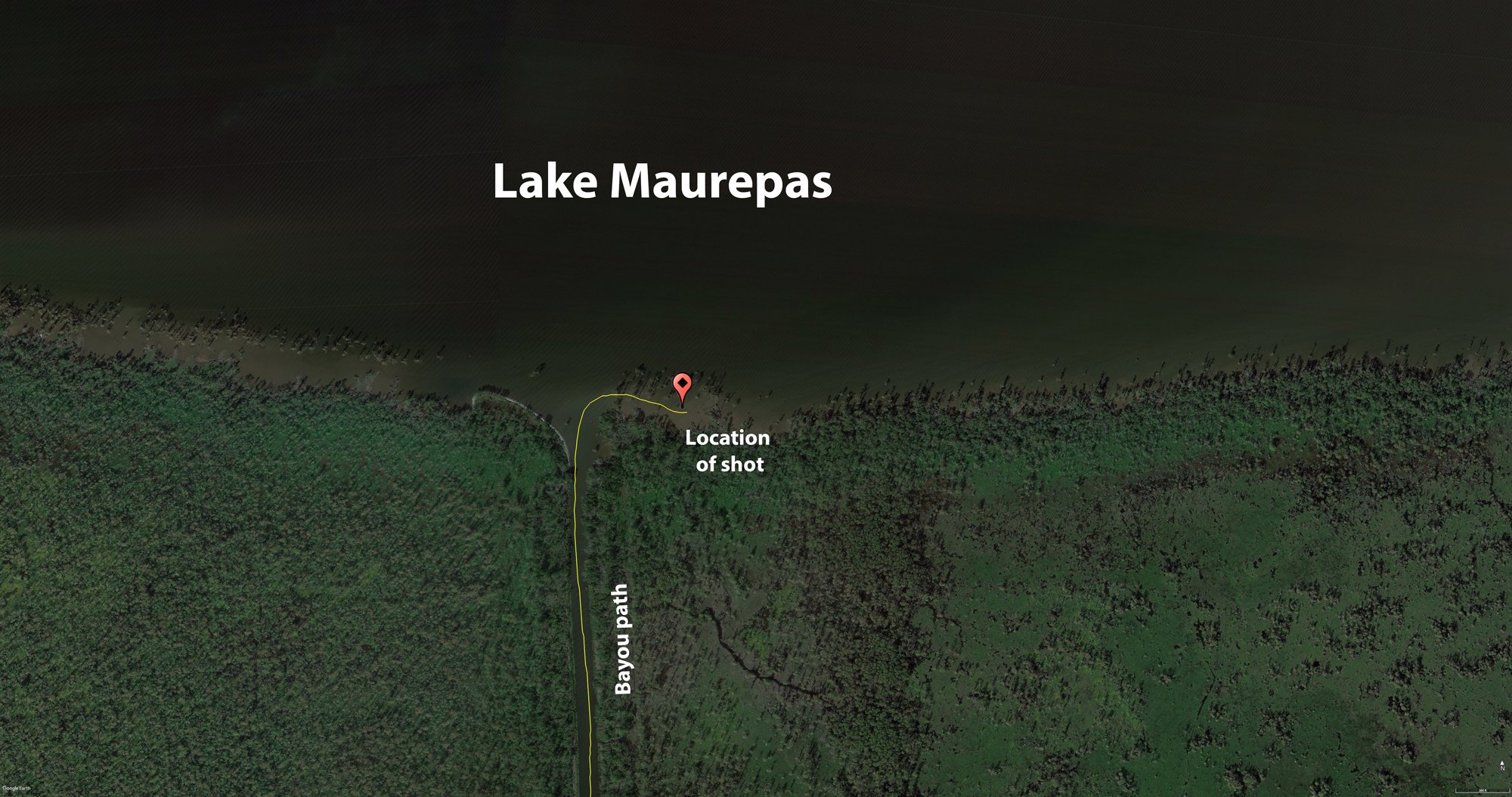
In this case, it's not a trail, it's a bayou. I'm rating it difficult because a boat or kayak or canoe is required to access the lake. In addition, all of the dangers of the swamp are present and need to be paid attention to. Alligators will generally steer clear of people as long as they're aware of your presence. All of the images shown here were taken along the south shore of the lake, in St. John the Baptist Parish. There is a boat ramp at GPS coordinates 30°04'42.7"N 90°32'44.7"W. Follow the bayou from the boat ramp north under I-10 to the lake, and then there are any number of opportunities along the shoreline.
GPS Coordinates & Elevation
Sea Level Ft. Elevation
Download KMZ Trail File
Click Here to download the KMZ file for this location.
Photography Tips
Amongst the cypresses, and depending on recent rains and the tide, lake depth near the shore will range from 3-4 feet to 8 feet or more. Once you've found an area you like, you can photograph from the boat, or, as I did, check the depth and if not too deep, photograph from the water. I recommend wearing some old sneakers or tennis shoes if you choose to get out of the boat. Moving around is more of a slow shuffle. The cypress roots cover much of the lake bottom near the shore, and knees can stick up beneath the water a few feet as well. You'll need to feel around for them with your feet.
I found neutral density filters helpful for extending the exposures to smooth ripples on the water, and a polarizer helpful for minimizing glare and haze.
Other images from Lake Maurepas


Directions
CLICK HERE to get driving directions to the boat launching point to get to Lake Maurepas
View In Google earth
EXIF Data
Focal Length – 35 mm
Exposure – 1.3 sec @ f 16.0
ISO – 100
Date – May 27th
Time – 6.45am
Best Time of Day to Shoot
For the most dramatic light, sunrise and sunset, golden hour, and blue hour are all outstanding here. Midday can be harsh, but if you're in a boat, it's a good time to explore the bayous around the lake, and tuck in under the cypresses and photograph in the shade there.
Best Time of Year
Spring and fall are the best times. In spring the trees area lush green, while in the fall, the cypress leaves turn a golden color. In both seasons, the temperatures are more conducive to working outdoors than the summer months where the heat and humidity can be particularly dangerous.
The above image was taken on May 27th
Lens(es) Needed
Wide angle, standard, and telephoto lenses all have a place here. Wide angle and standard lengths work best for the trees. If you're a wildlife photographer you'll want the telephoto lens.
The above image was taken with a 35mm focal length.
Birds-Eye View
Permits
Currently, there are no permits required.
Direction of the Shot
The direction of the shot is northeast around 15°.
Equipment Needed
A boat, kayak, or canoe.
Number of Other Photographers to Expect
This location is off of the beaten path and you will most likely be the only one at this location.
Weather
Cell Service
I have Verizon and cell service is good at this location.
Area Guides and Workshops
None