
Lake Maurepas
Near New Orleans, LA
LAKE MAUREPAS
A BRIEF SUMMARY OF LAKE MAUREPAS
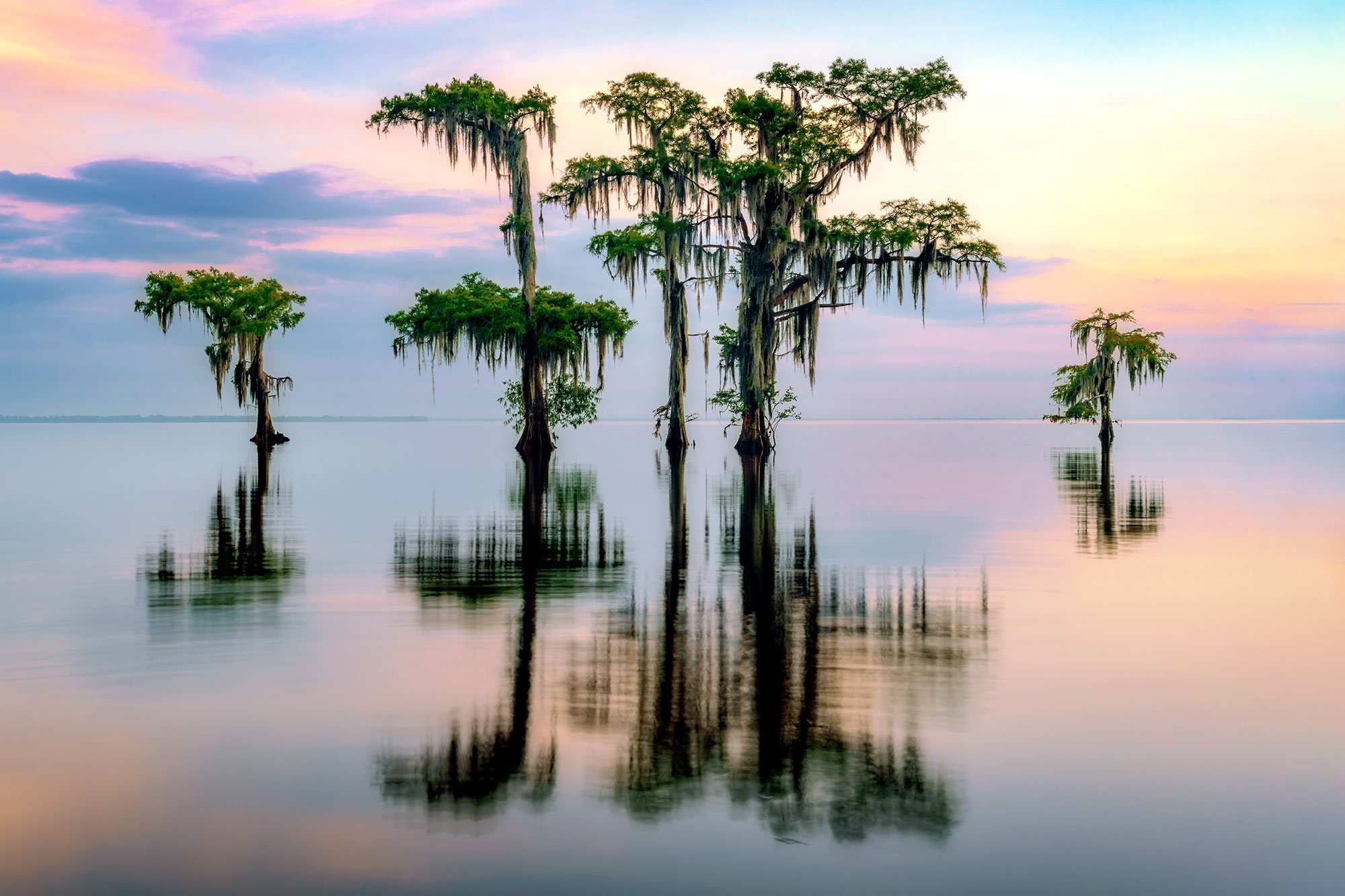
The Louisiana Bayou is not a place that quickly comes to mind when thinking of photogenic locations for landscape photography. But oh how wrong you'd be! Lake Maurepas is a challenging, but fun, landscape photo location. Tall cypresses grow out of the water, draped in Spanish moss, catching the southeastern sunlight as the sun rises or sets. It can be magical.
Lake Maurepas is round, shallow, brackish lake located just west of Interstate highway 55 and Lake Pontchartrain, and just north of Interstate 10 in southeastern Louisiana. The lake is fed by four rivers, the Blind River, Amite River, Tickfaw River, and Natalbany River. The south shore of Lake Maurepas, where "Cypress Symmetry" was taken, is part of the Maurepas Swamp Wildlife Management Area. The average depth of the lake is approximately 10 feet and the surface area is approximately 93 square miles.
Lake Maurepas features all of the typical swamp wildlife you would expect, including osprey, alligators, wood ducks, loons, deer, rabbits, and more. It's as much a wildlife photographer's dream as it is a landscape photographer's dream. The one catch is that access to the lake is by boat, canoe, or kayak only. There are no foot trails directly lakeside. There is a short, one-mile trail in the Maurepas Swamp Wildlife Management Area, but that does not take you past the lake, nor does it give you access to the gorgeous cypresses.
Photos and location summary by Rick Berk

Annual Subscription
Lifetime Membership
DATA POINTS INCLUDED WITH LAKE MAUREPAS SUMMARY
In this case, it's not a trail, it's a bayou. I'm rating it difficult because a boat or kayak or canoe is required to access the lake. In addition, all of the dangers of the swamp are present and need to be paid attention to. Alligators will generally steer clear of people as long as they're aware of your presence. All of the images shown here were taken along the south shore of the lake, in St. John the Baptist Parish. There is a boat ramp at GPS coordinates. Follow the bayou from the boat ramp north under I-10 to the lake, and then there are any number of opportunities along the shoreline.
Amongst the cypresses, and depending on recent rains and the tide, lake depth near the shore will range from 3-4 feet to 8 feet or more. Once you've found an area you like, you can photograph from the boat, or, as I did, check the depth and if not too deep, photograph from the water. I recommend wearing some old sneakers or tennis shoes if you choose to get out of the boat. Moving around is more of a slow shuffle. The cypress roots cover much of the lake bottom near the shore, and knees can stick up beneath the water a few feet as well. You'll need to feel around for them with your feet.
I found neutral density filters helpful for extending the exposures to smooth ripples on the water, and a polarizer helpful for minimizing glare and haze.
Wide angle, standard, and telephoto lenses all have a place here. Wide angle and standard lengths work best for the trees. If you're a wildlife photographer you'll want the telephoto lens.
The above image was taken with a 35mm focal length.
23 Ft. Elevation
Other Resources Available with Membership
KMZ Trail File
Directions
Best Time of Day to Shoot
Best Time of Year to Shoot
Equipment Needed
Permits Required
Direction of Shot
Google Maps Birds-Eye-View
Number of Photographers to Expect
Cell Service
Overnight Lodging/Camping
Nearby Restaurants
Area Guides and Workshops
Other Resources
LOCATION SUMMARIES WRITTEN BY PROFESSIONAL PHOTOGRAPHERS


