BOULDER BEACH

BOULDER BEACH

Acadia National Park, ME
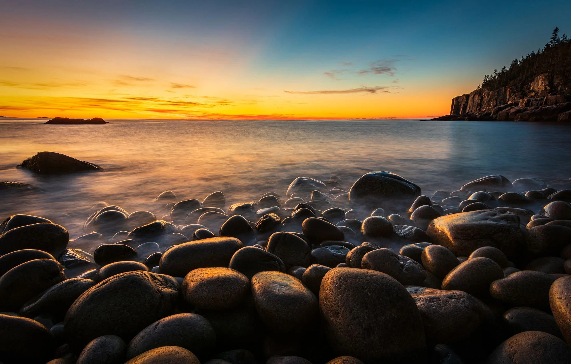
Image by Darron Franta @ www.frantaphotography.com


Boulder Beach is one of the absolute best spots on Mt. Desert island, the primary home of Acadia National Park, to capture a beautiful sunrise.

Each morning the sun will rise over the Atlantic and cast its warm glow on the smooth, rounded boulders that literally cover the beach at this location. It's not hard to take some magical shots here. However, the true impact of your image will likely depend on the wave action and the atmosphere you receive on the day you visit.

Photos and location summary by Darron Franta


Trail Difficulty - EASY

I would rate the difficulty of this trail as a 2 on a scale of 1-5 (with 5 being most difficult). The walk/trail down to Boulder Beach is short and relatively easy. However, it does have a few challenges pay close attention to.

As you leave the Ocean Path, you will need to descend a slight incline and scramble over some large rocks to reach the beach/boulders. Once there, you will need to navigate the rounded boulders and that can prove to be tricky. The challenge is not only walking on them, but also finding out that many can be slick, and some may also be loose and will shift or tilt when you step on them. If you are going there to shoot sunrise, this walk will likely be done in the dark with a headlamp so arrive early and just take your time and try not to rush.

If you do plan to shoot sunrise at this location, I would recommend visiting and scouting the area in the daylight so that you will know the exact path you should take in the predawn darkness. This will also help to acclimate yourself to walking on the boulders.


What Lens(es) Do You Need

There are many compositions available while at Boulder Beach, so I would bring a wide angle and medium telephoto lens.

The above image was taken with an ND filter @ 100 ISO, f20 at 16mm and 8 seconds.


Nuances of Shot

This shot is fairly straightforward. You simply need to find a location along the beach that is complementary to the sunrise, clouds and the lens that you are using. Experiment with different tripod heights and exposure settings.

Join Today
To View Full Location Summary


START YOUR NEXT ADVENTURE

2 Ways to Join


Annual Subscription

$34/year

Annual Renewal

Access To All Locations

Opt Out Anytime

Lifetime Membership

$99/one time

One-Time Charge

Access To All Locations

Never Expires


Our location summaries are written by experienced photographers - with practical information for planning your adventure - and with tips to getting the best shot


GPS Coordinates & Elevation

xx°27'5.80"N xxx°50'16.64"W

Sea Level Ft. Elevation


Directions

CLICK HERE to get driving directions to the Boulder Beach parking area

From Bar Harbor - from Bar Harbor, take Route 3 south out of town for 1.2 miles. Take a left on Schooner Head Rd. After you take this left, you will immediately veer to the right, staying on Schooner Head Rd. You will stay on this road for the next 2.5 miles. At the 2.5-mile mark, turn right and go 300 to 500 yards until you reach Park Loop Rd. where you will take a left. You will go through the Acadia National Park entrance and proceed for approximately 1.7 miles. While on Park Loop Rd., you will pass signs for Sand Beach and Thunder Hole.

After you pass Thunder Hole, you will see a sign and parking on your right for the Gorham Mountain Trailhead. Do not park here. Proceed slowly because approximately 500 ft past the Gorham Parking area, there will be …


Equipment Needed

Other than a sturdy tripod, there is no need for special equipment. A polarized filter and/or a graduated ND filter will also come in handy at this location.


Weather


Download KMZ Trail File

Click Here to download the KMZ file for this location.


START YOUR NEXT ADVENTURE

KNOW THE DETAILS BEFORE YOU GO

  • Best Time of Day to Shoot

    It is all about the light! We help you plan your trip and let you know if the location is a sunrise, sunset or anytime shot.

  • Best Time of Year

    Sunrise might be best in summer or the waterfall conditions are best for spring. We will let you know.

  • Direction of Shot

    Is the shot facing east or west? We provide this information to best understand the direction of the shot.

  • Google Maps Birds-Eye-View

    For each location we provide a birds-eye view to provide a better understanding of the layout and terrain of the location.

  • Photographers to Expect

    Ever show up to a great location to find there are too many photographers for the location? We will let you know how many to expect.

  • Permits

    Have you ever been in the field and wondered if you need a permit to be there? We provide information on when or if a permit is required.

  • Cell Service

    Being in the field can limit access to your phone service and important information. It is great to know when you can find coverage.

  • Camping Options

    We provide the closest camping (with direct links via Google maps) and lodging (with direct links to TripAdvisor).

  • Nearby Restaurants

    After a long day of shooting, it is great to know where you can grab a good meal and a cold refreshment. We share personal favorites.